|
||

|

|
|

|
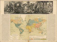
Striking German Wall Map of the World Featuring Giles Land and the Mountains of Kong
Fine nineteenth-century wall map of the world. The map is meant for instruction and education, displaying many facets of the study of geography in one densely-packed object.
The map was initially designed by Traugott Bromme, famous for his immigrant guides, and revised by C. F. Baur.
The large map shows the world’s landmasses on a Mercator Projection. It centers the Pacific, which is criss-crossed with lines showing the prevailing currents, famous explorers’ routes, and shipping lanes, as are all the world’s waters. There are also gyres in both the Atlantic and Pacific.
The geography appears relatively complete to a twenty-first-century eye. It is thickly labeled with mountains, rivers, cities, telegraph lines, and steamboat routes—the map is meant to convey a modern world that is in touch and on the move.
However, some of the geographical feature give the reader pause. These include the greatest cartographic myth of the nineteenth century, the Mountains of Kong in West Africa.
Greenland remains uncharted in its northern extremities. The Northwest Passage is shown, based on knowledge that was wrought from dozens of expeditions to find the waterway and to find fellow voyagers that had been lost in the seeking, like John Franklin and his men. Pack ice and winter ice is shown, displaying just how much was known about the Arctic.
Even so, there are also some strange lands in the Far North, like Gillis Ld (sometimes Giles Land) next to Spitzbergen (the Svalbard Archipelago). Indeed, this is the most extreme interpretation of the wandering island of Giles Land, showing it as much larger than other maps. However, it should be noted that Baur finished the toponym with a question mark, indicating that its extent and location was still unknown.
The emphasis on transport and communication is underlined by the additional insets and information that lines the top and bottom of the map. At the top are two diagrams showing the time differences among the world’s major cities, a hemisphere showing the world’s largest water mass (encompassing the South Pacific and South Atlantic), another showing the world’s landmasses, and a table of the distance between meridians at different latitudes. At the top center is another world map, this one showing the northern and southern hemispheres, and featuring steamships routes.
Along the bottom border are more inset maps including a world map with isogons, showing magnetic variation; a world map showing lines of the same high tide swell; a world maps showing wind patterns, Atlantic storm charts showing the common locations of squalls in winter and summer, and maps showing the Suez Canal and the Isthmus of Panama (with a proposed canal route).
This is a fascinating map that rewards close examination. It is a good representative of the ways mobility, communications, and geography were conceived in the increasingly interconnected late-nineteenth century.
This map includes one of the most curious cartographic mysteries of the nineteenth century, the mountains of Kong. The mountain range, in West Africa, usually stretches from roughly present-day Liberia as far Benin, and usually appears on or near the tenth parallel of southern latitude.
Geographers had long surmised that the Niger River of Africa must find its source in a mountain range. This hypothesis had circulated from at least the sixteenth century. Particularly in the late-eighteenth century, mapmakers began to include a line of hills or mountains in the interior of West Africa. Then, in his Travels in the Interior Districts of Africa (1799), Mungo Park asserted:
I gained the summit of a hill, from whence I had an extensive view of the country. Towards the south-east, appeared some very distant mountains, which I had formerly seen from an eminence near Marraboo, where the people informed me, that these mountains were situated in a large and powerful kingdom called Kong; the sovereign of which could raise a much greater army than the king of Bambarra.
Park’s popular account was accompanied by a map, A Map shewing the Progress of Discovery & Improvement, in the Geography of North Africa (1798), by none other than James Rennell, the meticulous mapmaker responsible for A Bengal Atlas (1779). Rennell’s map was the first to label the mountains as the “Kong mountains.” Rennell explained his choice in the appendix to Park’s book:
The discoveries of this gentleman…give a new face to the physical geography of Western Africa. They prove, by the courses of the great rivers, and from other notices, that a belt of mountains, which extends from west to east, occupies the parallels between 10 and 11 degrees of north latitude, and at least between the 2nd and 10th degrees of west longitude (from Greenwich). This belt, moreover, other authorities extend some degrees still farther to the west and south, in different branches…
After this map, many others began to adopt the Mountains of Kong. In 1889, however, French explorer Louis Gustave Binger led an expedition to the mountains. He followed the Niger River from Mali to Kong. A town of Kong was there, but the mountains were not. Thereafter, the feature began to dwindle on maps, but it was still featured in the Oxford Advanced Atlas as late as 1928.
Giles Land was first recorded by a whaler commanded by Cornelis Giles in 1707. The mysterious land in the Arctic was not reliably seen again for a century and a half. It ranged on maps east and northeast of Svalbard and eventually settled roughly 160 kilometers north of Kvitøya, which is in the east of the Svalbard Archipelago. Today, it is accepted that Giles Land as sighted in 1707 was likely Kvitøya itself, re-discovered and named by Johan Kjeldsen in 1876.
Giles’ sighting of a white-capped island quickly made its way onto maps, although Giles’ own description of the island is now lost (although a record of it from 1775 does survive). Gerard van Keulen included Commandeur Giles Land on a map of Svalbard in 1714. Other maps would call the island Giles, Gillies, Gilies, and Gillis. By the end of the eighteenth century, most maps showed the landmass in approximately the position of Kvitøya today, following van Keulen.
During his 1863-4 expedition to the area, Adolf Erik Nordenskiöld saw a large island at 79°N 26°E; he assumed it was Giles Land, although it was not in the position described by Van Keulen. However, it was likely Svenskøya, the westernmost island in the Kong Karls Land islands. Nordenskiöld was actually the most prominent in a string of land sightings that shifted Giles Land to the east and southeast of previous understandings. Baur, on his revision of Bromme’s map, showed the most extreme interpretation of Giles Land, portraying it as a massive, unfinished coastline just east of Svalbard and as large as the rest of the archipelago combined.
Most influential in the fixing of Giles Land was August Heinrich Petermann. In his Arctic maps of the 1870s he showed Giles Land at 81°30’N 36°E, far removed from where Giles had reported his sighting. This placed it farther to the north and east than van Keulen’s depiction.
Despite the fact that Petermann explained that this placement was only conjecture, other mapmakers quickly took up his placement of the island. Therefore, even when Kvitøya was located and named in 1876, many mapmakers retained Giles Land father north. A. M Brice wrote of the island in 1896, “It is true that you will find it in your maps to-day a degree and a half further north, but that seems to be mainly due to the waywardness of a German geographer and the complaisance of those English cartographers who believe in maps made in Germany.”
Frederick Jackson looked in the area described by Petermann in August 1897, during the Jackson-Harmsworth expedition to Franz Josef Land. He was turned back by ice but sighted no land and sounded deep water. Also in summer 1897, Salomon August Andrée passed over the ice in the area after a failed balloon journey toward the North Pole. He had consulted Bartholomew’s updated map of 1897, which included Giles Land in the Petermann location. However, he too found no island. Andrée and his companions tragically perished on Kvitøya, leaving their findings unknown for decades.
The island lived on, for example in the corrected Admiralty chart of the Barents and Greenland seas of 1908. However, the ice had largely kept ships away from Petermann’s coordinates, making absolute verification impossible. Frank Worsley, who had been with Shackleton on the Endurance expedition (1914-1917) searched for it (seeking both a Gilles Land and a Gillis Land) in 1925.
Andrée’s papers were found in 1930, which helped to clarify that Giles Land was certainly not where Petermann had placed it. Consensus began to cohere around Kvitøya being Giles Land, although a Soviet expedition in 1935 still looked for Gillis Land (at the Petermann coordinates and now thought to be a different island than Giles or Gilles Land near Svalbard). They again found no land and the mystery of Giles Land was finally laid to rest, although it remains an instructive lesson in how a geographic hypothesis can become an accepted feature on maps.
Traugott Bromme was a traveler and publisher best known for this immigration guides for German migrants. Born in Anger, in Saxony, Traugott was orphaned at a young age. He emigrated to the United States at age eighteen. There he studied medicine, traveled extensively, and supposedly served as a surgeon in the nascent Colombian Navy and was imprisoned in Haiti. He returned to Germany in 1824, where he became a partner in his brother-in-law’s bookshop in Dresden. He began to publish books on the topic of immigration at this time.
In 1833 Bromme returned to the United States, this time to Baltimore where he took up a partnership in a publishing house, Scheld and Company. Here he began to publish his guidebooks targeting German immigration to America, which included maps after those of Henry Schenck Tanner. By 1840, he had again returned to Germany, starting a bookshop in Stuttgart. In 1846 he once again sailed to America, spending three years there. By 1849, he was back in Germany and seemingly returned to publishing. All of his outputs were geographic in nature and include several wall maps.
Carl Fredrich Baur was a German map publisher based in Stuttgart whose flourished in the latter half of the nineteenth century. His work focused on maps and atlases, most of it with thematic or historical content. He is best known for his Atlas fur Handel und Industrie fur Kaufleute, Fabrikanten und Gewerbetreibende (1857), a pioneering industrial and commercial atlas.
![[ World in Two Hemispheres on Polar Projections ]](https://storage.googleapis.com/raremaps/img/small/99920.jpg)
![World [Rand, McNally & Company's Indexed Atlas of the World]](https://storage.googleapis.com/raremaps/img/small/100314.jpg)