
This item has been sold, but you can enter your email address to be notified if another example becomes available.


|
||

|

|
|

|
Stock# 81460
Description
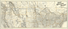
Interesting early road map of the region between Spokane and Medicine Hat, published for early motor tourism.
In one place, the roads end are connected by steamers across Lake Kootenay and the Kootenay River
On the verso is a map centered on the Canadian Rockies, illustrating the "Auto Circle Tour of the Canadian Rockies."
Condition Description
Folding map with original printed covers.
![[Route of the 1938 Westward Northwest Passage Cover] Map of the Northwest Territories 1929](https://storage.googleapis.com/raremaps/img/small/60046.jpg)

![[ Pacific Northwest - Northwest Passage ] Limes Occidentis Quivira et Anian. 1597](https://storage.googleapis.com/raremaps/img/small/71207.jpg)
![[British Columbia]. Routes of the Canadian Pacific Railway Company's Steamers British Columbia Coast Service](https://storage.googleapis.com/raremaps/img/small/83915.jpg)
![[ Lake Cavenaugh - Lake Creek - Skagit County ] Township No. 33 North, Range No. 6 East, W.M. Wash.](https://storage.googleapis.com/raremaps/img/small/101848.jpg)