


|
||

|

|
|

|
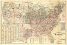
Mapping the Transmississippi West Following the Opening of the Transcontinental Railroad
Fine large format map of the United States, published by the General Land Office.
With the driving of the Golden Spike finalizing the completion of a Transcontinental Railroad on May 10, 1869, American commerce began to look more seriously at the commercial exploitation of the vast resources of the Transmississippi West. This map, prepared by General Land Office, provides one of the first comprehensive looks at the mineral transportation resources in the West on a large scale.
The map identifies Gold, Silver, Copper, Quicksilver and a number of other mineral resources, along with an overview of the existing and proposed railroads, along with a comprehensive look at the progress of the General Land Office Surveys and the establishment of Primary Baselines and Meridians.
The map includes a detailed treatment of a number of early Western railroads, mining districts, wagon roads, and future projected railroad lines.
The map was intended for widespread distribution to American and Foreign Governments and commercial interests and may fairly be called the map used by the US Government to market the Transcontinental Railroad for foreign investment, marketing and commerce.
The General Land Office (GLO) refers to the independent agency in the United States that was in charge of public domain lands. Created in 1812, it assumed the responsibilities for public domain lands from the United States Department of the Treasury. The Treasury had overseen the survey of the Northwest Territory, but as more area was added to the United States, a new agency was necessary to survey the new lands.
Eventually, the GLO would be responsible for the surveying, platting, and sale of the majority of the land west of the Mississippi, with the exception of Texas. When the Secretary of the Interior was created in 1849, the GLO was placed under its authority. Until the creation of the Forest Service in 1905, the GLO also managed forest lands that had been removed from public domain. In additional to managing the fees and sales of land, the GLO produced maps and plans of the areas and plots they surveyed. In 1946, the GLO merged with the United States Grazing Service to become the Bureau of Land Management.

![[ United States ] Etats-Unis de l'Amerique](https://storage.googleapis.com/raremaps/img/small/98821.jpg)
![(American Revolution) Geschichte der Revolution von Nord-America. Sammlung der besten Schriftsteller, welche die Geschichte, besondere Rechten, Sitten, und Gewohnheiten der Völker nach ihren Grundsätzen abgehandelt haben [with map:] Die Vereinigten Staaten von Nord=America. nach der Wm. Faden 1783. [History of the Revolution of North America. Collection of the Best Writers Who Have Discussed the History, Specific Laws, Customs, and Habits of the Peoples According to Their Principles [with map:] The United States of North America. According to Wm. Faden, 1783.]](https://storage.googleapis.com/raremaps/img/small/90124.jpg)