|
||

|

|
|

|
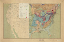
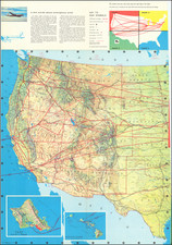
Rare and fascinating map of the United Sates, showing the country's railroads and time zones. This map was published in Palms, Los Angeles, by the Llewellyn College of Astrology and Publishing Company, using a Rand McNally Desk Map of the United States as a base.
The map is fascinating for showing the convoluted nature of time zones. While they sometimes follow state boundaries or other clear divisions, they oftentimes meander and divert course. This meandering is usually determined by the railroads - two close-together cities, which do not have direct railroad connections, are likely to be separated. In addition, cities on the border can be in one time zone but use another.
The map is further interesting for its imprint from the Llewellyn College of Astrology and Publishing Company. This was a Los Angeles-based publisher that specialized in the soft planetary sciences. A number of their other publications are advertised on the map.
Dating
Rand Mcnally uses a code system for cataloging their maps, in which the appearance of a letter or number in the map's code can be used to date the map. The code uses a letter-to-year system, which starts at 1919 as "A" and counts up from there. The code for this map is 1N34, with N corresponding to 1932.
Rarity
We were unable to trace this map in OCLC or through other means. Large vintage folding maps of the United States focusing on time zones are conspicuously uncommon.
Rand McNally & Co. is a large American map and navigation company best known for its annual atlases. The company got its start in 1856, when William Rand opened a print shop in Chicago. He was joined in 1858 by a new employee, Andrew McNally. Together, the men established their namesake company in 1868. Originally, the company was intended to print the tickets and timetables for the trains running to and through Chicago; their first railway guide was published in 1869.
By 1870, they had shifted from just printing to publishing directories, travel guides, and newspapers. Their first map appeared in 1872 in a railway guide. The map was produced using a new wax engraving method, a cheaper process that gave the company an edge.
By 1880 Rand McNally had entered the education market with globes, wall maps, and geography texts for students. In 1923, Rand McNally published the first Goode’s World Atlas, named after its editor, Dr. J. Paul Goode. For generations afterward, this would be the standard classroom atlas.
In 1899, William Rand left the company, but McNally and his family remained, controlling the company for over a century. In 1904, they published their first road map intended for automobiles and by 1907 were publishing Photo-Auto Guides, which combined photography and mapping to help drivers. In 1924, they produced the Auto Chum, a precursor to their famous road atlases. Rand McNally would remain the leader in road maps and atlases throughout the twentieth century.
In 1937, Rand McNally opened its first store in New York City. Ever on the frontier of technology, Rand McNally pioneered the scribing process for printing tickets in 1958 and printed their first full-color road atlas in 1960. Arthur Robinson developed his now-famous projection of Rand McNally in 1969. By the 1980s, the company was exploring digital reproduction and digital databases of maps for truckers. In the 1990s, they lead the charge to develop trip-planning software and websites. Today, most of its products are available online or in a digital format, including maps for tablets and phones.