


|
||

|

|
|

|
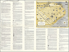
Fine and uncommon antique map showing the water supply for the city of San Francisco, demonstrating the ever-increasing development of the Spring Valley Water Works that now extend past Alameda and Santa Clara Counties to the Sierra Nevadas. This map was engraved by George Baker and designed by George Allardt, printed in 1875.
The map is highly detailed, showing the Bay Area and extending northwards to Clear Lake, eastwards to Lake Tahoe, and southward along the San Joaquin River. The map focuses on water supply lines, with the Clear Lake and Calaveras conduits (and their branches) already built, although many additional proposed branches spread out around the map. Also shown are the branches of the railroads, county lines, and other interesting details.
George Baker was one of the most important early California lithographers and illustrators. He was based in San Francisco, and his maps are a testament to life in the early statehood period on the West Coast. He published a series of water supply maps for the San Francisco Board of Supervisors in 1875, of which this is a general map showing how already-built developments could be improved.
![[ Eden Township ] Residence and Farm of Lewis Knox, Residence and Farm of Lewis Knox, Eden Tp., Alameda County, California](https://storage.googleapis.com/raremaps/img/small/102040.jpg)
![[San Mateo, California] St. Matthews Hall, Church & Rectory, San Mateo, California, Rev. A.L. Brewer, Rector](https://storage.googleapis.com/raremaps/img/small/88381.jpg)
![[ Bringing Water To San Francisco ] General Map of the Spring Valley Water Works Hermann F.A. Schussler Chief Engineer. 1899](https://storage.googleapis.com/raremaps/img/small/98206.jpg)