|
||

|

|
|

|
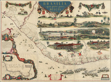
One of the Most Elegant 17th-Century Dutch Wall Maps and a Map Having a Special Place in the History of Cartography (Peter Whitehead, British Museum). The Superlative Mapping of Brazil in a Previously Unknown First Wall Map State.
Exceptional Dutch wall map of Brazil, published by Rombout van den Hoeye in Amsterdam in 1652 and heightened in gold. The map is the defining cartographic work produced during the colonization of Brazil by the Netherlands and is remarkable both for the geographical information displayed, compiled by the German scholar Georg Marggraf, as well as for its decorative elements that show scenes of everyday life in the colony, based on artwork commissioned for the map from Frans Post. These elements incorporated onto the map redefine the history of Brazil cartographically, artistically, and scientifically.
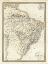
The map shows the Brazilian coastline from Salvador to Natal in fantastic detail. This region, controlled by the Dutch at the time of the map's production, contains endless place names, toponyms, geographical indicators, coats of arms of the captaincies, and more. Offshore, numerous ships add to the cartographic detail, and four great naval battles are shown between Dutch and Iberian warships. Four vignettes, produced for this map by Frans Post (the first European to paint landscapes of the Americas), show life in the colony in the upper right. At the top of the map, a number of indigenous species are depicted and named, exemplifying Marggraf's celebrated contributions to natural history, while nearby a magnificent title overlooks the rest of the map. In the lower-left, an inset map places the Dutch colony within the context of the rest of Portuguese Brazil, showing the region from Rio de Janeiro and Sao Paulo up to northern Brazil.
This map's outsized importance is not just limited to Brazilian history, but this example is also a "missing link" in the history of Dutch cartography. This is a previously unknown first state of the second edition of the map, and the first edition to be produced as a wall map. The only prior edition was published by Johannes Blaeu and Caspar van Barlaus in 1647 and copied directly from manuscripts produced by Marggraf. However, the Blaeu map was originally intended for publication in a book and appeared on a number of differently-sized sheets.
Previous scholarship held that two further editions of this wall map existed, one published by Hugo Allard in 1557 and 1559, and one published by Clemendt de Jonghe in 1664. However, our map provides a missing link between these two maps: it includes five plates from the Allard edition, as well as an imprint plate (in the lower-right corner) bearing the inscription "Rombout van den Hoeye excudebat Anno 1652." This latter plate was reissued in what would become the De Jonghe edition. This implies that Rembourt van den Hoeye was likely a progenitor of the two later projects, something that has not been recognized before. This matter is discussed further below.
The map was a centerpiece in the Dutch effort to expand their claims to Brazil. By enticing scientists, artists, and other men of letters to the colony, the Dutch West India Company encouraged publication and dissemination of works that attempted to draw more settlers. It is to this effort that we can credit the creation and design of this map.
This is the first wall map edition of the map and the final known edition to be published before Dutch Brazil was retaken by the Portuguese in 1654.
Historical Context
Georg Marggraf (also spelled Marcgrave or Marcgraf) was invited to Dutch Brazil by the governor-general of the colony, Count Johan Maurits of Nassau-Siegen, where he formed one of the most important members of the count's entourage (Brienen, 2010). Marggraf served from 1638 until his death in 1643, not only gathering cartographic but also scientific information, drawing on his background as a polymath.
As previously mentioned, this work's importance to the history of Brazil is not only cartographic. The use of Frans Post's artwork as a basis for the vignettes reflects the influence of another member of Count Nassau-Siegen's educated circle. These vignettes are at once evocative of Dutch Brazil, as well as informative, as they provide imagery not known in the rest of Post's surviving ouevre. For example, the Tapuyas are shown engaging in cannibalism, which is not documented in any of Post's paintings, thus leading several scholars to wonder if this was based on an eyewitness event.
The scientific aspect of this map can be seen above those vignettes. It is for good reason that Baron Cuvier called Marggraf the ablest and most precise natural historian to operate in remote countries during the sixteenth and seventeenth centuries. At the top of the map, we see many of the mammals, birds, insects, and reptiles that populate Brazil, with their names provided.
The Dutch West India Company and Dutch Brazil
The Dutch West India Company (GWC) was founded in 1621 as a complement to the Dutch East India Company and was granted a monopoly in the Dutch Caribbean and allowed to operate anywhere between West Africa and easternmost New Guinea, including the Americas. The GWC first arrived in Brazil in 1624, capturing Sao Salvador but shortly after being expelled.
The first successful invasion, in 1630, led to the development of Dutch Brazil, establishing itself in Recife and rapidly expanding into nearby towns. The lenient Dutch practices of freedom of worship and superior governance, when compared to those of the Portuguese colonialists, encouraged many Europeans, and even Portuguese, to settle in Dutch regions. Count Maurits was given control of the colony in 1637, and his love for the country was evident in the number of artists and naturalists whom he invited to Brazil. Under his rule, the colony prospered, with the population continuing to grow rapidly and peace
The decline of the colony commenced due to the resentment of wealthy Portuguese planters in conquered areas, who were forced to rebuild their property using high-interest Dutch loans. Other issues included the departure of Maurits due to a failed colonization attempt in Chile, and the Portuguese were able to start reconquering the land. The Dutch would finally be expelled in 1654, only twenty-four years after their arrival. This short-lived occupation had consequences lasting to the present day--consequences relating to the distribution of wealth, the history of Brazilian Jewish communities, and the gold rush that would eventually propel the Brazilian economy.
Frans Post and the Decoration of the Map
The four vignettes in the upper right of the map are based on the artwork of Frans Post, who was the first European artist to paint landscapes of the Americas. These are of particular importance in the map. In contrast to the decorative elements of the vast majority of 16th-century European maps, which commonly featured allegorical imagery or Europeanized visions of the New World, these representations show everyday life in Dutch Brazil as rendered by an eyewitness.
Starting with the topmost of the four vignettes, this lengthy image shows two hunting scenes, a battle scene, and, most importantly, a cannibal scene, all representing the Tupinamba indigenous peoples of Brazil. Only two of Post's paintings show Tupinambas, thus this engraving expands the Dutch source of information available on the Tupinambas. The Tupinambas had long been accused of cannibalism by Europeans, but this was oftentimes reported through unreliable sources. The depiction here may represent an accurate historical narrative of the Tupinambas provided by Post, or, also, this vignette could be embellished by Blaeu's influence in order to make the map more salable.
The rest of the vignettes display little artistic license, and the depiction of the sugar mill has been termed accurate enough to be used as a blueprint. The views of a plantation and village are equally remarkable for their representation of early Brazilian settlement.
Unpublished Contemporaneous Golijath Mapping of Brazil
Curiously, Marggraf was not the only cartographer employed by the Dutch authorities during this period. Cornelis Golijath, one of the best Dutch mapmakers of his age, was also serving in the colony between 1638 and 1641 with the instruction to make a general map of the Dutch possessions. However, his map was never published, and survives as only two manuscript copies executed by Johannes Vingboons, partner to the Bleau family. Comparison of Marggraf's map to the Golijath manuscript reveals little indication of collaboration: Golijath incorporated more place names, while topographic detail is greater in the map supplied by Marggraf. However, Marggraf and Golijath must have been aware of each other and worked together to some extent, so it is strange that the map published by Blaeu does not incorporate Golijath's research, and that no reference is made to Golijath.
Editions and States of the Map
This map endured a complicated and extensive printing history, of which three editions are known. The map, like most 17th-century Dutch wall maps, is very rare and was produced in a limited run through several states, some of which are rarer than others.
- First edition, by Caspar van Barlaus. Issued as four disparately sized plates, covering only the coastline and the lowermost of the two vignettes. Appeared in Rerum per octennium in Brasilia. . . historia in 1647, published by Johannes Bleau. One holding at the BM and offered by Reiss in 2005.
- Second state. Four additional sheets added, which allows for a wall map to be created if joined. Minor alterations to the plates, including additional captions and the inclusion of more palms in the lower two vignettes. Includes French, Dutch, and Latin text, usually included at the base. Published by Johannes Blaeu in 1647, reprinted at least once in 1657. Three of the sheets from this state were reissued in the 1662 Latin and 1665 Dutch editions of his Atlas Maior. The complete map appears in the British Library (twice), the Rostock University Library, and the Deutsche Staatsbibliothek.
- Previously unknown second edition, the last state published during the existence of Dutch Brazil. First issued in 1652 by Rombout van den Hoeye and known only in the present example. Several minor engraving changes exist when compared to the Blaeu edition, but the most important change is the issuance on nine regularly sized sheets of paper. This is the first edition that was conceived as a wall map.
- Clemendt de Jonghe reissued the van den Hoeye map in 1664 using eight new plates but conserving the lower right plate (the plate that is different in the Allard example). This state is known in the BL, the Rotterdam Maritime Museum, the Ministry of Foreign Relations in Rio de Janeiro, and the William Clements Library at the University of Michigan.
- Hugo Allard reissues the den Hoeye map in 1659, using at least four (but not more than eight) of the nine copper plates produced by den Hoeye. The sheet in the lower right, containing the title engraving, is printed using a different copperplate. The Allard edition is present in the collections of the BNF and the University of Leiden, and it also appeared for sale at Sotheby's in 1986.
It should be noted that there are a number of ways to interpret this publication chronology, with some suggesting that the Allard was possibly first issued in 1651. It is also possible that the van den Hoeye map was also first issued in 1651, though there is no firm evidence of either of these conjectures.
The Publication of this Map and Collaboration Between the Den Hoeye and Allard Families
As previously outlined, between five and eight of the plates in this map also appear in a nine-sheet map by Hugo Allard, with the remaining plate appearing in the later edition by Clemendt de Jonghe alongside eight newly engraved plates. We have been able to gather several further pieces of information:
- Nine plates of a Brazil map appeared in the Rombout den Hoeye divorce sale in 1662, three years after Allard used a majority of the plates in his map. The price was 200 florins.
- The Allard family and the den Hoeye family collaborated on several previous maps. Schilder notes that the imprints of Huych (Hugo) Allard and Francois den Hoeye (Rombout's father) appear on the same, undated world map.
- The Allard family and the den Hoeye family were also close socially. At Allard's 1648 baptism of his son Carel, Rombout served as witness, a honorific title reserved for a close family acquaintance with high standing in the community.
- Rombout den Hoeye is not known as a primary engraver, although Hugo Allard produced a number of original works.
- The Allard family inventory of 1708 lists "8 plates to Brasil."
- Both the den Hoeye map and the Allard map have dates that look like they could have been revised from "1651".
- The impetus for engraving new plates would have diminished after 1654, when the colony of Dutch Brazil collapses.
We recognize several possibilities for how to resolve these facts:
- Allard and Van den Hoeye shared eight sheets of the map and each made their own imprint. At some later point, Van den Hoeye re-engraved a new set of plates before his 1662 inventory.
- Allard or Van den Hoeye engraved an example of the map in 1651 that has not survived. The partners originally shared the map but had a falling out, and Allard kept the plates. Van den Hoeye immediately re-engraved all nine plates but had enough leftover sheets from the first run of printing (that he shared with Allard) that he mixed between the two sets.
- Van den Hoeye "pirates" Allard's hypothetical 1651 map, removing only the title sheet and adding his own name. Having success selling this, he engraved his own eight additional plates.
This map revolutionizes our knowledge of three great cartographic publishing houses but leaves enough questions unanswered to continue the need to search for new, unrecorded, pieces of evidence.
Rarity
This is the only known example of a previously-unknown first pure wall map edition of the Marggraf map. The discovery of this map reshapes our knowledge of the printing history of this map, as it was previously held that only the Blaeu maps were published while Dutch Brazil still existed. Furthermore, it shows that the Allard edition is actually the final edition of the map to be engraved.
No mention of this van den Hoeye edition is made in any of the literature consulted. No example can be traced in any of the major institutions, including the BL, BNF, or LOC. No examples are listed in OCLC or RBH. Previously unknown, and an apparently unique survival.
Kleerkoper & Van Stockum 1914-1916, p. 1131
P.J. Whitehead, 'The Marcgraf Map of Brazil', The Map Collector, XL, 1987, pp. 17-20
Schilder, Gunther. Three World Map by Francois van Den Hoeye... 1981
Georg Marcgraff (1610-1644) was a German astronomer and naturalist. In 1637, he was appointed astronomer of a company being formed to sail to the Dutch colony in Brazil. He accompanied Willem Piso, a physician and the newly appointed governor of the Dutch possessions in that country. Later, Marcgraf worked for Johannes Maruitiius of Nassau, who allowed Marcgraf to explore and later mapa considerable part of Brazil. He arrived in Brazil in early 1638 and undertook the first zoological, botanical, and astronomical expedition there, exploring various parts of the colony to study its natural history and geography. He later explored the coast of Guinea, where he died in 1644
During his time in Brazil, Marcgraf and Cornelis Goliath created a map of Brazil, under the sponsorship of Johan Maurits, which was completed in 1643. This map remained the most important ad accurate cartographic representation of Brazil until the 19th century. The Marcgraf Map—actually a series of maps—is illustrated with engravings that offer panoramas of Brazilian life. The illustrations in the map were probably based directly on the drawings of Frans Post, during his 7 years in Brazil as part of the Dutch occupation of the region.
![[Ilha da Santa Catarina to Bombinhas]](https://storage.googleapis.com/raremaps/img/small/59598.jpg)
![[ Brazil ] Brasilia Lusitanorum in XIV praefecturas divis. Per N. Sanson](https://storage.googleapis.com/raremaps/img/small/97912.jpg)