|
||

|

|
|

|
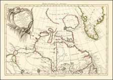
Early Dutch Sea Chart of the Americas
Rare sea chart of the Western Atlantic and contiguous parts of Northeastern North America and Northern South America, published by Hendrick Doncker in Amsterdam.
The east-oriented chart shows the West Atlantic seaboard from roughly Paraiba in the south to Newfoundland in the north. In the east, it includes the Azores and the Cape Verde Islands.
The chart was based on a previous work of ca. 1650 by Theunis Jacobsz, drawn at a time when the Dutch West India Company was losing its fight for control of Brazilian ports and when the New Netherland colony was thriving. Doncker took Jacobsz’s frame and updated the toponyms and geography throughout; for example, he includes Gebroken Lant for Long Island and redraws the shores of New Netherland. The Amazon and St. Lawrence rivers are also updated in their portrayals.
The Dutch Golden Age and the expansion of trade
The Dutch experienced what has been referred to by historians as a Golden Age in the seventeenth century, although this was achieved via investment and participation in the human slave trade. The term can apply to the extraordinary volume and quality of Dutch art in this period, to the prominence of Dutch traders in international commerce and finance, as well as to the dominance of Dutch geographers and publishers, who led the European map and atlas trade throughout the century.
Dutch trade focused both east and west. The Moluccas, just west of Papua, were of importance for they were the vaunted Spice Islands, originally the only source in the world for nutmeg, mace, and cloves. The Portuguese were the first Europeans to gain power in the East Indies, trading for spices in the Moluccas and controlling the spice market in Europe.
The Dutch wanted in on the lucrative trade, but they also had to contend with the Portuguese. The first Dutch expedition, led by Cornelis de Houtman in 1595, avoided India, the Strait of Malacca, and the Moluccas—Portuguese strongholds—in favor of the Sunda Strait. The Dutch set up their trade centers on the island of Java, at Bantam and, later, Batavia. After Houtman, the second Dutch expedition (1598-1600) quickly set sail for the East Indies. It was followed by five others. In 1602, the most powerful of these merchants and the Dutch government, the States General, created the Dutch East India Company (VOC), a monopoly to control the East Indies trade.
Meanwhile, other merchants had their eyes on the Atlantic. Here, the Dutch had to contend with the trade monopolies of the Portuguese and the Spanish. The Dutch began to strike at their colonies in the West Indies and in South America. Many of these privateers were funded by the West India Company, founded in 1621. Run by directors, like the VOC, the West India Company (WIC) was given its own monopoly over trade with Africa and the Americas. With the support of the States General, the WIC established outposts on the African coast and then ferried human cargo across the Atlantic.
The WIC gained footholds in the Americas thanks to captains like Piet Heyn, who seized a Spanish treasure fleet near Cuba in 1628. The company began to make settlements in Brazil in the 1630 but had to give them up to the Portuguese in 1654. They had more success in the Caribbean, where they set up holdings in Guyana, Aruba, Curacao, and Saint Martin. New Netherland, now New York, began as a company province in 1623 and was ceded to the English in 1667.
States and rarity
Doncker first issued the chart in 1659 with a different cartouche and slightly different title: Pascaerte van Brazil en Nieu Neder Landt. It was part of his Zee-Atlas, no example of which survives. A second plate dates from ca. 1668 (Burden says 1672) with an oval cartouche and the title: Pas Caart van Brazil en Nieu-Nederland. A third plate came into use in 1676; it is larger in size and has a cartouche with a scale in the lower center.
This is an example of a second state. The chart is rarely-seen on the market. This is the first time we have offered the chart.
Hendrik Doncker was a prominent bookseller in Amsterdam best known for his sea charts and nautical atlases. He issued his own original charts, which he updated frequently, and also worked with colleagues like Pieter Goos, for example to produce the pilot guide, De Zeespeigel. He died in 1699, after fifty years in business. His plates then passed to Johannes van Keulen.
![[Revolutionary War Plans of New York, Boston, Charleston, Delaware River to Philadelphia & Havana] Various Plans and Draughts of Cities, Towns, Harbours &c . . .](https://storage.googleapis.com/raremaps/img/small/83450.jpg)