


|
||

|

|
|

|
Searching for the Northwest and Northeast Passage
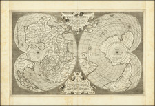
Fine example of Blaeu's signature map of the Arctic Region, with distinctive cartouches.
Blaeu's well-known map of the North Pole includes Arctic North America, Scandinavia, and northern Asia. It was one of the most accurate seventeenth-century polar maps and is remarkable especially for the mesmerizing loxodromic lines that radiate from the pole.
The information for this map is based on the discoveries of Barentsz, Baffin, Frobisher, Hall, Davis, and others. In particular, this map incorporates the discoveries of Thomas James along the southern and western shore of Hudson's Bay in 1631-32.
While these men sought the elusive Northwest or Northeast Passage, the map as shown here suggests a diminishing number of possibilities through which such a passage could travel. However, there remain unfinished coastlines in Greenland, Spitzbergen, and Nova Zembla. The east coast of Asia is also rounded, suggesting a passage around it.
The geography shown here is quite exacting for the time. It does not include popular North Atlantic cartographic chimeras like Frisland or Hy Brasil. However, it does plot Bus or Buss Island. This island originates in reports about Martin Frobisher’s third voyage, specifically George Best’s A True Discourse of the Late Voyages of Discoverie of a Passage to Cathaya (1578). One of Frobisher’s ships, the Emmanuel, which was a busse, hence the island’s name, supposedly sailed along the island on its homeward journey in 1578. Hakluyt included a description of the island in his Principal Navigations (1598). It was variably sighted and sought by seventeenth-century navigators and John Seller wrote charted it his English Pilot (1671). The Hudson’s Bay Company (HBC) sent an expedition after it in 1675, but they found nothing. By the eighteenth-century, cartographers supposed the island was fabulous or sunken, demoting it to a navigational hazard. A further voyage in 1791 finally proved its non-existence.
The map includes eight compass roses. These are connected with the loxodromic lines. Loxodromes, also known as rhumb lines, are lines of consistent bearing—they intersect meridians (lines of latitude) at the same angle. On a Mercator projection, rhumb lines appear straight, hence the utility for navigators of that type of chart. Here, on a polar projection, they are curved. That is because, although they can appear straight on a chart, to actually approach meridians at the same angle, one would sail a curved line that arced toward the pole, eventually arriving at the pole itself.
The map is also highly decorative. Ships can be found at sea, and there are two especially intriguing cartouches. In the upper left corner is a large cloudbank; windheads protrude from the edges, blasting the Arctic with icy gusts. To the left is a naked man gnawing at a hunk of meat, an association of the region with wildness. To the right is an aged man leaning over a stew, old man winter tucking in for the season.
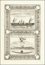
In the lower right two Inuit men with bows and quivers of arrows point to a bear and two foxes. Map cartouches like this would have been some of the only visual information available to readers about Arctic peoples.
States
The map appeared in three known states:
- c. 1638 Without the dedication on the left-hand side
- 1645. With dedication to GVILIELMO BACKER DE CORNELJI , signed by Joan Blaeu. No other alterations.
- undated in Burden. c. 1650? With Groenlandia named.
This is an example of a third state. Burden recognizes the third state of this map only in the corrections issued in Volume II of his important reference work, The Mapping of North America, he was unaware of this state when Volume I was published.
The search for a Northeast Passage to the eighteenth century
A Northeast Passage was a popular topic for states and navigators from the sixteenth century, just like the more well-known Northwest Passage. In 1553, Hugh Willoughby, with backing from London merchants, sailed north. Willoughby’s crew got separated from their navigator, Richard Chancellor, rendering them lost. Russian fisherman found their frozen bodies the following summer.
Jacon van Heemskerck sought the Northeast Passage beginning in 1596, accompanied by Willem Barentsz as pilot. They discovered what they called Spitsbergen, which is now known as part of the Svalbard Archipelago. Their ship became locked in the ice and they were forced to winter in situ, the first time a ship had done so. In the spring, they escaped in open boats; Barentsz died, but van Heemskerck made it to the coast of Lapland.
By the seventeenth century, Russian traders had found a continuous sea route, the Mangazeya Seaway, from Arkhangelsk to the Yamal Peninsula. From there, adventurers would portage to the Gulf of Ob. However, sailing around land farther east proved difficult, if not impossible, in the early modern period. Voyages pioneering parts of the Northeast Passage continued, however. For example, Fedot Alekseev and Semyon Dezhnev sailed from the Kolma River, around the Chukchi Peninsula, and into the Pacific in 1648, proving that Asia and North America were not connected.
The search for a Northwest Passage to the eighteenth century
Today, the most famous expeditions in search of the Northwest Passage are those that took place in the mid-nineteenth century, including the ill-fated Franklin voyage. However, finding a passage to Asia via a northern route was a centuries-old endeavor. Indeed, Ptolemy, in the second century CE, suggested that there was a sea route between Europe and East Asia. The expansion of the Ottoman Empire in the fifteenth century led Columbus and De Gama to explore for alternative access to Asian markets to the west and south. The information they brought back led Europeans to look to the northwest and northeast for a shorter, yet treacherous and icy, way to China.
The first recorded search for the Northwest Passage was the voyage of John Cabot in the late fifteenth century, following in the wake of Norse voyages to North America that occurred in the eleventh century. With the support of Bristol merchants, Cabot landed in Newfoundland in 1497. The following year, in a voyage supported by Henry VII, he left with five ships and 200 men; the squadron never returned. In the early sixteenth century, John’s son, Sebastian, led several voyages to what is today Canada.
Early English and French voyages to North America were constantly on the look-out for passages that might lead to the Pacific. For example, Jacques Cartier led an expedition at the behest of Francis I of France. Cartier ranged over the coasts of Newfoundland and the Gulf of St. Lawrence; he was the first European to contact Prince Edward Island, which, alas, was not the Northwest Passage. A second voyage took Cartier to the location of Quebec, which he claimed for France.
The Spanish too sought the Northwest Passage. They originated the toponym of the Strait of Anian, a displacement of a place name from Marco Polo’s writings, which soon caught on with mapmakers across Europe. Conquistador Hernán Cortés funded the voyage of Francisco de Ulloa from Acapulco north in search of the western entrance to the Passage. He got to the Gulf of California before turning back.
The English did not mount many expeditions during the reign of Henry VIII, who was more focused on the power balance in Europe, but under Elizabeth I many voyages set out to the northwest. Martin Frobisher, a privateer, led three attempts on the Passage in 1576, 1577, and 1578. He thought that he had discovered gold in Frobisher Bay, on Baffin Island, but it turned out to be iron pyrite.
John Davis also led three expeditions north, in 1585, 1586, and 1587. He sailed along Greenland, Baffin Island, and Labrador, as well as charted the Davis Strait. He also found the entrance to Hudson Strait, which would be named for Henry Hudson thirty years later.
John Smith searched for the passage while sailing up Chesapeake Bay in 1608. He did not find it, but he wrote to his friend Hudson that he thought it still might lie just to the north. In the employ of the Dutch East India Company (VOC), Hudson set out in 1609. He first ventured up the Hudson River; while this was again no Northwest Passage, it did help the Dutch to colonize New York, or New Amsterdam as they called the settlement. In 1610, Hudson tried again, this time entering the eponymous Hudson Bay. His ship was trapped in the ice, his crew mutinied, and Hudson, his son, and seven others were set adrift in a small boat, never to be seen again.
One of the mutineers who escaped trial was Robert Bylot, who accompanied Thomas Button on his Arctic voyage in 1612-13. Bylot also accompanied William Baffin to the Arctic in 1615 and 1616; their reports of Baffin Bay were considered fantastic until revisited by John Ross two hundred years later.
Two further explorers, Luke Foxe and Thomas James, went on separate voyages in 1631. Foxe investigated the western shore of Hudson Bay, while James visited the south. These were the last English attempts on the Passage for a century, but the names of Frobisher, Davis, Hudson, Button, Baffin, Foxe, and James are still sprinkled liberally in the high latitudes of the Arctic. The Hudson’s Bay Company (HBC) was founded in 1670, but they focused on trade, rather than exploration, until new attempts were made in the 1720s.
Joan, or Johannes, Blaeu (1596-1673) was the son of Willem Janszoon Blaeu. He inherited his father’s meticulous and striking mapmaking style and continued the Blaeu workshop until it burned in 1672. Initially, Joan trained as a lawyer, but he decided to join his father’s business rather than practice.
After his father’s death in 1638, Joan and his brother, Cornelis, took over their father’s shop and Joan took on his work as hydrographer to the Dutch East India Company. Joan brought out many important works, including Nova et Accuratissima Terrarum Orbis Tabula, a world map to commemorate the Peace of Westphalia which brought news of Abel Tasman’s voyages in the Pacific to the attention of Europe. This map was used as a template for the world map set in the floor of the Amsterdam Town Hall, the Groote Burger-Zaal, in 1655.
Joan also modified and greatly expanded his father’s Atlas novus, first published in 1635. All the while, Joan was honing his own atlas. He published the Atlas maior between 1662 and 1672. It is one of the most sought-after atlases by collectors and institutions today due to the attention to the detail, quality, and beauty of the maps. He is also known for his town plans and wall maps of the continents. Joan’s productivity slammed to a halt in 1672, when a fire completely destroyed his workshop and stock. Joan died a year later and is buried in the Westerkerk in Amsterdam.

![Hemisphere Septentrional du Globe Terrestre Veu en concave l'oeil estant au Pole AntArctique . . . 1696 [and] Hemisphere Superieur du Globe Terreste pour l'Horizon de Paris Veu en convexe l'oeil etant pose au zenith et a distance infinie du plan de projection . . . 1697](https://storage.googleapis.com/raremaps/img/small/85541.jpg)