|
||

|

|
|

|
From Shirley:
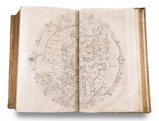
This extraordinary world map in twelve sheets was published in Antwerp in 1612 according to documents of Plantin. It is doubly unusual, for not only is the whole world presented within a single sphere from a south polar viewpoint but all the land masses are drawn in reversed form as mirror images of themselves. Place names, however, read normally from left to right. The engraving is associated with the artist Jan Wiericx.
Pisani, whose portrait appears on the map, was a native of Naples and emigrated to Antwerp where he gained renown as a mathematician and astronomer, corresponding with Galileo. His world map seems to have been published separately although it might have been prepared to illustrate one of several treatises on projectional techniques such as Pisani's Astrologia of 1613, or the Opticornm by Francois d'Aiguillon in the same year. The engraving is of a high standard, with many ships decorating the sea. The spandrels contain figures representing the rape of Proserpine, Fortune's chariot, the cortege of Neptune and Amphitrite, and other scenes, with grand classical figures supporting the globe. The date of 1610 is noted on a large land mass to the west of South America, possibly referring to De Quiros' voyage across the Pacific in that year.
Only four copies of Pisani's work have been recorded, as listed below. On one copy discovered in Belgium in the 1880s, the top left-hand cartouche concludes with the words dicat humillimus servus Octavius Pisani not to be found on the copies in Paris and London. Articles on Pisani and his work throw little further light on this unusual composition. Note the derivative published in 1637 by Pieter Verbiest, described under Entry 344.
Examples: Bibliotheque Royal, Brussels, Service Historique de la Marine (Proof), National Maritime Museum, BN Res Ge(?)
![[Map of the World on a Globular Projection Exhibiting Particularly the Nautical Researches of Capn. James Cook, F.R.S. with all the Recent Discoveries to the Present Time carefully Drawn by A. Arrowsmith . . . ]](https://storage.googleapis.com/raremaps/img/small/94140.jpg)