


|
||

|

|
|

|
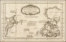
Interesting and highly detailed map of the Southern Hemisphere extending to the equator. The regions shown include substantial detail, with attention to topographic details in the mountainous regions of southern Africa and Patagonia.
A very attractive and interesting map, it illustrates the total lack of knowledge regarding Antarctica. The early 1800s were a time of discovery in the Southern Ocean, immediately following Cook's three voyages which discovered numerous new islands. In 1822, James Weddell would reach the South Orkney Islands and push south of the Shetlands islands towards the Antarctic peninsula, reaching 74 degrees south (three degrees further than Cook's southernmost latitude, as reported on the map) without sighting land. Unfortunately, he passed into the Weddell Sea, missing Antarctica. The first true sighting had occurred three years prior to this at a lower latitude by a Russian expedition.
This map originally appeared in Thomson and Company's New General Atlas. It is one of the best large format English maps of the period.
John Thomson (1777-ca. 1840) was a commercial map publisher active in Edinburgh. He specialized in guide books and atlases and is primarily known for his Atlas of Scotland (1832) and the New General Atlas, first published in 1817 and reissued for the next quarter century. The New General Atlas was a commercial success—it was also published in Dublin and London—and it compiled existing geographic knowledge in compelling ways for a wide audience.
His Atlas of Scotland introduced new geographic information and was the first large-scale atlas of Scotland to be organized by county. It provided the most-accurate view of Scotland available before the Clearances. Work on the atlas began in 1820 and led to Thomson’s bankruptcy in 1830 due to the high costs of gathering the latest surveys and reviewing the required materials. Despite the publication of the atlas, Thomson declared bankruptcy again in 1835.
![[ Pacific Northwest - Northwest Passage ] Limes Occidentis Quivira et Anian. 1597](https://storage.googleapis.com/raremaps/img/small/71207.jpg)

![A Chart of the South Sea [1st English Map of the Pacific Ocean]](https://storage.googleapis.com/raremaps/img/small/47376.jpg)