|
||

|

|
|

|
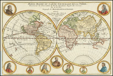
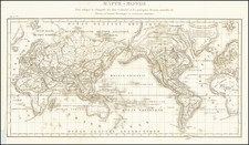
Unrecorded state of John Seller's map of the Pacific Ocean, the first English map of the Pacific.
John Seller's map of the Pacific Ocean is the first English map of the Pacific.
First issued in 1675, it is a map of exceptional rarity and importance for the region. Abel Tasman's discovery of States Land (New Zealand) in 1642 is noted, with 9 place names, including 3 Kings Island, Sand Hills and Steep Point. To the West, Anthony Van Diemen's Land is shown with 8 place names.
Japan, The Land of Eso and Companies Land are shown, as are the Ladrones and a projection of Nova Guinea which foretells its being shown as attached to Australia.
The islands discovered by Hernand Galego in 1576 appear, as do many other islands in the South Pacific. Nice detail along the west Coast, from Fretum Anian to the Straits of Magellan.
California is shown as an island, with San Diego, P. Sir Francis Drake, Santa Barbara, Catalina, Mendocino and Monte Rey all named. The Gulf Coast, and the Southeastern US are also shown, extending to Port Royal and naming C May, C Francis, Augustin B, Florida, B. Tompa (Tampa) and B. Joseph, etc.
While Seller was known to have based some of his work on Goos, this map appears to loosely derive from Jansson's map of 1650, although many features (California, Companies Land, Tierra Del Fuego) are substantially updated and revised, and Jansson had no coverage of the Gulf Coast or East Coast, making the map unique in its coverage.
The present example is an unrecorded variant, most likely post-dating the two known states of the map. Burden notes the following states:
- 1675: Imprints reads By John Seller Hydrographer to the King's Most Excellent Majestie
- 1677: Imprint reads. By J. Seller, J. Colson, W. Fisher, J. Atkinson & J. Thornton
It is possible that this chart was issued as early as 1672. Phillips notes a copy of the chart in a copy of Atlas Martimus dated [1672 ?], which lists the title of the map as issued here, but with no credit to Seller or the Seller consortium as noted above (Phillips 4153). The 1675 edition listed by Phillips also lacks the imprint (4154). However, no "John Seller" imprint is listed, so it is possible that Phillips' description is incomplete. It is also possible that the map was intended to appear in the Atlas Maritimus of 1708, which contains other charts lacking the imprint below the title, however we were not able to locate any recorded examples.
Rarity
The map has not appeared in a dealer or auction catalogue in the past 30 years.
The popular misconception of California as an island can be found on European maps from the sixteenth through the eighteenth centuries. From its first portrayal on a printed map by Diego Gutiérrez, in 1562, California was shown as part of North America by mapmakers, including Gerardus Mercator and Abraham Ortelius. In the 1620s, however, it began to appear as an island in several sources. While most of these show the equivalent of the modern state of California separated from the continent, others, like a manuscript chart by Joao Teixeira Albernaz I (ca. 1632) now in the collection of the National Library of Brasil shows the entire western half of North Americas as an island.
The myth of California as an island was most likely the result of the travel account of Sebastian Vizcaino, who had been sent north up the shore of California in 1602. A Carmelite friar, Fray Antonio de la Ascensión, accompanied him. Ascension described the land as an island and around 1620 sketched maps to that effect. Normally, this information would have been reviewed and locked in the Spanish repository, the Casa de la Contratación. However, the manuscript maps were intercepted in the Atlantic by the Dutch, who took them to Amsterdam where they began to circulate. Ascensión also published descriptions of the insular geography in Juan Torquemada’s Monarquia Indiana (1613) (with the island details curtailed somewhat) and in his own Relación breve of ca. 1620.
The first known maps to show California as an island were on the title pages of Antonio de Herrera’s Descripción de las Indias Occidentales (1622) and Jacob le Maire's Spieghel Der Australische Navigatie (1622). Two early examples of larger maps are those by Abraham Goos (1624) and another by Henry Briggs, which was included in Samuel Purchas’ Hakluytus Posthumus or Purchas his Pilgrimes (1625). In addition to Briggs and Goos, prominent practitioners like Jan Jansson and Nicolas Sanson adopted the new island and the practice became commonplace. John Speed’s map (1626-7), based on Briggs’ work, is well known for being one of the first to depict an insular California.
The island of California became a fixture on mid- and late-seventeenth century maps. The island suggested possible links to the Northwest Passage, with rivers in the North American interior supposedly connecting to the sea between California and the mainland. Furthermore, Francis Drake had landed in northern California on his circumnavigation (1577-80) and an insular California suggested that Spanish power in the area could be questioned.
Not everyone was convinced, however. Father Eusebio Kino, after extensive travels in what is now California, Arizona, and northern Mexico concluded that the island was actually a peninsula and published a map refuting the claim (Paris, 1705). Another skeptic was Guillaume De L’Isle. In 1700, De L’Isle discussed “whether California is an Island or a part of the continent” with J. D. Cassini; the letter was published in 1715. After reviewing all the literature available to him in Paris, De L’Isle concluded that the evidence supporting an insular California was not trustworthy. He also cited more recent explorations by the Jesuits (including Kino) that disproved the island theory. Later, in his map of 1722 (Carte d’Amerique dressee pour l’usage du Roy), De L’Isle would abandon the island theory entirely.
Despite Kino’s and De L’Isle’s work, California as an island remained common on maps until the mid-eighteenth century. De L’Isle’s son-in-law, Philippe Buache, for example, remained an adherent of the island depiction for some time. Another believer was Herman Moll, who reported that California was unequivocally an island, for he had had sailors in his offices that claimed to have circumnavigated it. In the face of such skepticism, the King of Spain, Ferdinand VII, had to issue a decree in 1747 proclaiming California to be a peninsula connected to North America; the geographic chimera, no matter how appealing, was not to be suffered any longer, although a few final maps were printed with the lingering island.
John Seller was one of the most notable map and instrument makers in England in the late-seventeenth century. He was especially known for the sea charts, many of which featured in his influential English Pilot and Atlas Maritimus. Seller was born in London in 1632. His father was a cordwainer and John was apprenticed to Edward Lowe, of the Merchant Taylors’ Company. He was made free of that company in 1654. Later, he also was made a brother of the Clockmakers’ Company, which housed several instrument makers. He started business as a compass maker but expanded his offering to include navigational instruments and charts.
Seller’s career was halted temporarily, and fantastically, when he was tried for high treason in 1662. He was accused of involvement in a plot led by Thomas Tonge. While Seller likely only unwisely repeated rumors, he was convicted. The other conspirators, who did admit some degree of guilt, were executed, but Seller maintained his innocence and, via insistent petitions, he eventually secured his release from Newgate Prison.
This episode did not seem to slow Seller’s rise too much, however. Seller was granted a royal license to publish English-language maritime atlases. This gave him a near-monopoly and led to his being named hydrographer to the King in 1671. Although the point of the project was to produce English charts of Dutch dominance and bias, Seller ended up using many Dutch plates as his base material. The first volume of The English Pilot was published in 1671, followed by more volumes as well as The Coating Pilot (1672) and the Atlas Maritimus (1675). Seller was commercially successful, but some of his projects required further support. The English Pilot was eventually taken over by John Thornton and William Fisher, for example, and his proposed English atlas only produced maps of six counties.
Seller’s sons, John and Jeremiah, followed in their father’s profession. Seller also apprenticed several promising young men, including Charles Price, with whom his sons partnered. Through Price, Seller can be seen as the founding figure of an important group of London mapmakers that included Price, John Senex, Emanuel Bowen, Thomas Kitchin, and Thomas Jefferys.