|
||

|

|
|

|
Coronelli's Map of the New World
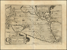
A very fine map of the Western Hemisphere including the discoveries made by Abel Tasman in Australia and an early image of the New Zealand coastline, plus California as an Island. The treatment of the Northeastern Coast of Asia and Japan are also quite unusual, including a representation of Terra di Iesso, the mythical land bridge which was frequently shown to extend from Asia to Alaska, with only the Straits of Anian separating the two continents.
California is featured as an island on the second Sanson model, with only C. Blanco named. To the north is Stretto d'Anian, northwest is Terra di Iesso, ("Scoperta dagli Holland, l'Anno 1643"), and farther west is Giaponi. The American west is dominated by Nuovo Mexico, in which live the Apaches, seemingly the only Indian tribe named. In the Pacific, portions of New Zealand, Van Diemens land, Carpentaria, and Nuova Guinea are shown. Shirley extolls the two world sheets as "a worthwhile addition to any collection. They combine the most up-to-date cartographical information with elegant engraving and retained accompanying decoration."
The decorative borders include co-ordinates and descriptions of signs of the zodiac.
The map is from Coronelli's Atlante Veneto. The Atlante was professionally designed as a continuation of Blaeu's Atlas Maior and by 1701 was extended to embrace up to twelve volumes.
The popular misconception of California as an island can be found on European maps from the sixteenth through the eighteenth centuries. From its first portrayal on a printed map by Diego Gutiérrez, in 1562, California was shown as part of North America by mapmakers, including Gerardus Mercator and Abraham Ortelius. In the 1620s, however, it began to appear as an island in several sources. While most of these show the equivalent of the modern state of California separated from the continent, others, like a manuscript chart by Joao Teixeira Albernaz I (ca. 1632) now in the collection of the National Library of Brasil shows the entire western half of North Americas as an island.
The myth of California as an island was most likely the result of the travel account of Sebastian Vizcaino, who had been sent north up the shore of California in 1602. A Carmelite friar, Fray Antonio de la Ascensión, accompanied him. Ascension described the land as an island and around 1620 sketched maps to that effect. Normally, this information would have been reviewed and locked in the Spanish repository, the Casa de la Contratación. However, the manuscript maps were intercepted in the Atlantic by the Dutch, who took them to Amsterdam where they began to circulate. Ascensión also published descriptions of the insular geography in Juan Torquemada’s Monarquia Indiana (1613) (with the island details curtailed somewhat) and in his own Relación breve of ca. 1620.
The first known maps to show California as an island were on the title pages of Antonio de Herrera’s Descripción de las Indias Occidentales (1622) and Jacob le Maire's Spieghel Der Australische Navigatie (1622). Two early examples of larger maps are those by Abraham Goos (1624) and another by Henry Briggs, which was included in Samuel Purchas’ Hakluytus Posthumus or Purchas his Pilgrimes (1625). In addition to Briggs and Goos, prominent practitioners like Jan Jansson and Nicolas Sanson adopted the new island and the practice became commonplace. John Speed’s map (1626-7), based on Briggs’ work, is well known for being one of the first to depict an insular California.
The island of California became a fixture on mid- and late-seventeenth century maps. The island suggested possible links to the Northwest Passage, with rivers in the North American interior supposedly connecting to the sea between California and the mainland. Furthermore, Francis Drake had landed in northern California on his circumnavigation (1577-80) and an insular California suggested that Spanish power in the area could be questioned.
Not everyone was convinced, however. Father Eusebio Kino, after extensive travels in what is now California, Arizona, and northern Mexico concluded that the island was actually a peninsula and published a map refuting the claim (Paris, 1705). Another skeptic was Guillaume De L’Isle. In 1700, De L’Isle discussed “whether California is an Island or a part of the continent” with J. D. Cassini; the letter was published in 1715. After reviewing all the literature available to him in Paris, De L’Isle concluded that the evidence supporting an insular California was not trustworthy. He also cited more recent explorations by the Jesuits (including Kino) that disproved the island theory. Later, in his map of 1722 (Carte d’Amerique dressee pour l’usage du Roy), De L’Isle would abandon the island theory entirely.
Despite Kino’s and De L’Isle’s work, California as an island remained common on maps until the mid-eighteenth century. De L’Isle’s son-in-law, Philippe Buache, for example, remained an adherent of the island depiction for some time. Another believer was Herman Moll, who reported that California was unequivocally an island, for he had had sailors in his offices that claimed to have circumnavigated it. In the face of such skepticism, the King of Spain, Ferdinand VII, had to issue a decree in 1747 proclaiming California to be a peninsula connected to North America; the geographic chimera, no matter how appealing, was not to be suffered any longer, although a few final maps were printed with the lingering island.
Vincenzo Maria Coronelli (1650-1718) was one of the most influential Italian mapmakers and was known especially for his globes and atlases. The son of a tailor, Vincenzo was apprenticed to a xylographer (a wood block engraver) at a young age. At fifteen he became a novice in a Franciscan monastery. At sixteen he published his first book, the first of 140 publications he would write in his lifetime. The order recognized his intellectual ability and saw him educated in Venice and Rome. He earned a doctorate in theology, but also studied astronomy. By the late 1670s, he was working on geography and was commissioned to create a set of globes for the Duke of Parma. These globes were five feet in diameter. The Parma globes led to Coronelli being named theologian to the Duke and receiving a bigger commission, this one from Louis XIV of France. Coronelli moved to Paris for two years to construct the King’s huge globes, which are 12.5 feet in diameter and weigh 2 tons.
The globes for the French King led to a craze for Coronelli’s work and he traveled Europe making globes for the ultra-elite. By 1705, he had returned to Venice. There, he founded the first geographical society, the Accademia Cosmografica degli Argonauti and was named Cosmographer of the Republic of Venice. He died in 1718.
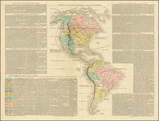
![[New General Map of North and South America Showing the Routes of Kruzenshtern and Lisyansky] НОВАЯ ГЕНЕРАЛЬНАЯ КАРТА СѢВЕРНОЙ И ЮЖНОЙ АМЕРИКИ СЪ ПОКАЗАНІЕМЪ ПУТЕЙ КРУЗЕНШТЕРНА И ЛИСЯНСКАГО](https://storage.googleapis.com/raremaps/img/small/58490.jpg)