|
||

|

|
|

|
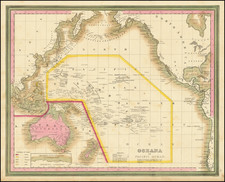
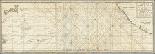
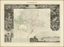
Scarce early map of Oceania, detailing a vast region encompassing Australia, New Zealand, and the numerous islands scattered across the Pacific Ocean.
The map highlights Australia, labeled here as Australie ou Nouvelle Hollande, indicating its former name, New Holland, used by early European explorers. The delineation of Australia's coastline suggests a detailed understanding, likely derived from the exploratory voyages of figures such as James Cook and Matthew Flinders. The interior, less known at the time, is sparsely detailed, reflecting the limited inland exploration of the continent by Europeans up to that point.
New Zealand is depicted with both its North and South Islands, named here as Ile du Nord and Ile du Sud, with a level of accuracy that implies a familiarity with the coastline, which had been extensively charted by the end of the 18th century.
The myriad of Pacific Islands are spread across the map, with major groups such as the Iles Carolines, Iles Sandwich (now known as the Hawaiian Islands), and others identified, showing the extent of European navigational and cartographic knowledge of the region.
Overall, Tardieu's map offers a comprehensive snapshot of the geographical understanding of Oceania in the first half of the 19th century, prior to the more intensive colonization and exploration activities that would follow later in the century.
Ambroise Tardieu was an important French cartographer and engraver.
He produced a number of excellent large format maps, including a revised edition of Aaron Arrowsmith's 4-sheet map of the United States. T
Tardieu came from a family boasting a number of fine engravers, and was trained from an early age by his uncle, Pierre Alexandre Tardieu (1756–1844), a leading French engraver. Showing considerable talent in this field, Ambroise persevered and became a celebrated engraver of portraits. In addition he was appointed as geographical engraver for the French government, for which he received a small stipend. In order to eke out this meagre wage, he began to trade in prints, books and maps. He is remembered for more than 800 portraits engraved through his career, many depicting scientists of the period.
Tardieu published a number of atlases, one of which appeared in 1842 and was titled Atlas universel de geographie, ancienne et moderne/dresse par Ambroise Tardieu pour l'intelligence de la Geographie universelle par Malte-Brun.