|
||

|

|
|

|
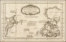
Jacob von Stählin's Influential Update To G.F. Müller’s Seminal Map of the North Pacific
Rare 1773 state of Gerhard Friedrich Müller's influential map illustrating the Russian encounters in northwestern North America.
First published in 1754, Müller's map introduced the outlines of the Alaskan Peninsula, based upon Russian explorations from the preceding decade. Widely copied by other mapmakers, Müller's map became one of the foundational maps of the region for the next two decades, as well as underpinned the debate with French mapmakers regarding the existence of the Sea of the West and other speculative theories which dominated the cartographic landscape of the regions in the 1750s and prevailed until Cook's explorations twenty years later.
In 1773, Jacob von Stählin published the first meaningful updates to G.F. Müller's original map, including significant revisions based on later explorations by the Russians which radically re-shaped the cartographic knowledge of the region.
Müller's map was initially issued to counter the claims made by Joseph Nicolas De L’Isle, who had worked in Russia for decades before returning, or absconding, to France, and Philippe Buache. The two had issued a controversial map in June 1752 that claimed there was a vast inland sea—the Sea of the West—and trusted in the dubious reports of Admiral Fonte (see below).
The map stretches from Nova Zembla to Baffin Bay, showing a huge swath of the North Pacific. It provides one of the best cartographic depictions of the Northwest Coast prior to the surveys of James Cook on his final voyage (1776-1780), based on the findings of the First and Second Kamchatka Expeditions (1728-1730, 1733-1743) and (for the first time in this 1773 map) the updated information derived from the voyage of Ivan Synd in the 1760s. Müller was a member of the Second Kamchatka Expedition, during which he scoured Siberian archives for overlooked material.
There are tracks of several ships in the frigid northern waters. These include:
- Three Russian ships which arrived at Kamchatka in 1648, led by Semen Dezhnev. He led the group from the Kolyma River south of the Anadyr River. He described having sailed around a rocky promontory, which was most likely the Chukotskiy Peninsula. This was the first time Europeans has sailed around the eastern tip of Asia. However, Dezhnev’s reports remained unused and his achievement only vaguely understood until found by none other than Müller in archives in Yakutsk.
- The route of Captain Vitas Bering on his two North Pacific expeditions (1725-30, 1733-43). Bering was a Danish sailor who served in the Russian Navy. The First Kamchatka Expedition, which began in 1725, aimed to explore the extent of Siberia and to determine a route to America. The voyage was long and difficult; the crew traveled nineteen months overland from St. Petersburg before even reaching the Pacific coast at Okhotsk. From there, they sailed northeast along the coast of Kamchatka until they reached what would later be known as the Bering Strait.
Bering and his crew sailed around East Cape (today known as Cape Dezhnev) and saw that the coast turned back west toward Russia. He concluded that Asia and America were not connected and, although the expedition would spend another winter at Kamchatka, Bering was unable to locate any land to the east of the East Cape. The crew returned to St. Petersburg in 1730, after five years away.
After criticism for not making contact with America, Bering proposed the Second Kamchatka Expedition. However, during the voyage his ships were separated, weather was poor, and the crew became exhausted and sick. Bering himself became ill and eventually died on what is now known as Bering Island, near the coast of Kamchatka. Despite the deaths of nearly half of the crew, the expedition did eventually return to St. Petersburg with scientific and geographic information. They had traced the panhandle of Alaska, the Aleutian archipelago, opening the North Pacific to further Russian exploration.
- The route of Lieutenant Ivan Synd (here Sindo) in 1764, 1765, 1766, 1767, and 1768. Synd, who has sailed on the Second Kamchatka Expedition, was in search of the Northwest Passage, but he also hoped to clarify to what extent western Alaska was a peninsula or an archipelago.
In this 1773 state, Muller's map has been extensively updated by von Stählin. The massive peninsular outline has been erased. In its place are many islands—this is one of the first portrayals of the complex network of islands that make up the Aleutians.
On the west coast of North America several other navigators are mentioned. These include Sir Francis Drake, who landed in California during his piratical circumnavigation, the first for an Englishman (1577-1580). Farther north, three inlets mention three other navigators—Martin Aguilar, Juan de Fuca, and Admiral Fonte—whose findings were still under suspicion and are therefore mentioned, yet downplayed, on this map.
Aguilar was a Spanish captain who sailed with Sebastian Vizcaino on a reconnaissance expedition up the California coast in 1602-3. Aguilar, commanding the Tres Reyes, was blown off course, to the north. When the seas calmed, Aguilar reported that he had found the mouth of a large river. Some eighteenth-century geographers conjectured that the river was the entrance to the Sea of the West, although here Müller instead has it as the mouth of a River of the West. This river is one of the most notable features on the map. It connects from the Pacific to Hudson’s Bay and offers a strong suggestion of a navigable Northwest Passage. Whereas Müller abandoned the grandiose Sea of the West that appeared on Buache and De L’Isle’s 1752 map (and their later maps), he kept the idea of an inland waterway that could connect Atlantic and Pacific.
Juan de Fuca is the Castilianized name of Greek navigator Ioánnis Fokás (Phokás). Little archival evidence survives of Fuca's career, but a chance meeting with an English financier, Michael Lok, in Venice in 1596 gave birth to rumors of Fuca's voyages in the Pacific. Fuca reported that he had been sent north from New Spain twice in 1592 in search of the Strait of Anian. The Spanish Crown failed to reward Fuca's discovery of an opening in the coast at roughly 47° N latitude and Fuca left the Spanish service embittered. His story lived on in Lok's letters and eventually was published in Samuel Purchas' travel collection of 1625. In 1787, the present-day Juan de Fuca Strait was named by the wife of naval explorer Charles William Barkley, making permanent a label that had previously just been hopeful conjecture.
Müller, De L’Isle, and Buache—a cartographic controversy
Joseph Nicholas De L'Isle spent much of his career in Russia, where he helped to found the Russian Academy of Sciences. While there, he had access to the latest findings of Russian explorers and was at the center of Russia's geographic establishment; for example, he helped produce the first Russian atlas, the Atlas Russicus, with Ivan Kyrilov.
De L’Isle was not the only foreign savant attracted to the Russian Court. Gerhard Friedrich Müller was a German linguist and historian. He also helped to found the Academy of Sciences at St. Petersburg, where he taught Latin and geography. He also recruited across Western Europe on behalf of the Academy, and served as its Secretary. As noted above, he also served on the Second Kamchatka Expedition.
De L’Isle returned to Paris in 1747 with a large map collection, an event that drew some criticism from Russian academicians who thought he had absconded with delicate materials. One of these academicians was Müller, who had served as the translator between Bering and De L’Isle when they met before the departure of the Second Kamchatka Expedition, for which De L’Isle prepared maps and materials.
Müller was not only scandalized that De L’Isle had taken sensitive documents, but that the De L’Isle-Buache map of June 1752 was so erroneous. In an anonymous pamphlet published first in French in 1753 and then translated into German and English, Müller represented himself as a Russian Sea Officer (he was neither Russian nor a naval officer). The Officer explained that De L’Isle had not reviewed all the journals from the expedition and therefore made mistakes, specifically in the truncated tracks of Bering’s ship and the inclusion of strange lands at 75°N. Müller was also annoyed that De L’Isle had not shared letters in his possession about the discoveries of one Admiral de la Fonte.
On the 1752 map, a Lac de Fonte is connected to a series of lakes and a Rio de los Reyes. Admiral de Fonte supposedly sailed to the area in the mid-seventeenth century. The first mention of Fonte appears in two letters published in London in 1708 in two issues of The Monthly Miscellany or Memoirs for the Curious. The Fonte letters had been reprinted by Arthur Dobbs in his 1744 An Account of the Countries adjoining Hudson's Bay and were mentioned in other travel accounts. De L'Isle's copy of the letters came from Lord Forbes, British ambassador to Russia, as he explained in a memoir, Nouvelles Cartes des Decouvertes de l'Amiral de Fonte (Paris, 1753). He also read of them in Henry Ellis' account of the 1746-7 expedition to Wager Inlet.
The letters recounted that Fonte had found an inlet near 53°N which led to a series of lakes. While sailing northeast, Fonte eventually met with a Boston merchant ship, commanded by a Captain Shapley. One of Fonte's captains, separated from the Admiral, reported he had found no strait between the Pacific and the Davis Straits, yet had reached 79°N, helped by local indigenous peoples. This story, with its suggestion of water passages connecting the Pacific Northwest with the east, inspired hope in some and doubt in others in the mid-eighteenth century. A few, like Irish mapmaker John Green, thought the entire story a farce. Many, including De L'Isle and Buache, thought the information conformed neatly to other recent discoveries and included Fonte on their map.
Between writing his pamphlet as a Russian Sea Officer in 1752 and releasing the first state of this map in 1754, Müller seems to have reviewed the evidence and decided to minimize Fonte’s presence. His name is only shown near an opening in the coastline, and Fonte has a “pretended” journal, that is “according to Mr. de Lisle.” Müller’s skepticism is evident.
In addition to skepticism, Müller was modest about his map, “My work herein has been no more than to connect together, according to probability, by points, the coasts that had been seen in various places” (as quoted in Williams, 262). Modesty aside, however, Müller’s map is a landmark of Alaskan cartography and is part of an important story in the European exploration of the North Pacific.
The Bering Strait, Stachtan Nitada, and the Northwest Passage
In the 1760s, Russian fur traders discovered more and more of the Aleutian Islands, some of which are shown in von Stählin's map. In 1764, Lieutenant Ivan Synd led his own voyage to the Bering Sea in search of a navigable passage from the Pacific through the Arctic. He produced several maps, all but one of which have been lost. The map that does survive shows a series of islands nearly touching Kamchatka, not a peninsula.
As a result of Synd’s findings, Jacob von Stählin, secretary to the Russian Academy of Sciences, created this 1773 state of Müller’s map which converts the large peninsula to a string of islands. This was then reduced for inclusion in the Academy’s calendar. It appeared in a German edition and was soon thereafter reproduced in an English edition in 1774; the latter was entitled, “A Map of the New Northern Archipelago discover’d by the Russians.”
One of the most enduring, and controversial, details of this map is the toponym Stachtan Nitada on the North American mainland. This appears to the be the second use of the name; the first was a little-known 1767 map by midshipman Filip Vertyuglov which includes Stachtan Nitada where Cape Gvozdev had been, just as it is here.
Stachtan Nitada is supposedly a place at which Synd landed and is near the sighting of the Alaskan mainland by the Russians in 1730. Stählin’s book and map excited members of the Royal Society of London, who ensured that the German language publication was translated into English by the end of 1774.
However, Stachtan Nitada’s precise location and importance remained unclear to explorers, none more so than James Cook. Cook carried the English translation of Stählin’s map with him on this third voyage, which was focused on finding the Northwest Passage. What interested Cook was the strait between Stachtan Nitada and the nearest island to the west. It seemed to Cook and others planning his third voyage that this could be an entrance to a Northwest Passage.
When Cook arrived in search of the islands and passage in 1778, he found no such place. As J.C. Beaglehole, Cook’s twentieth-century editor, explains:
…no one could be too hard on Stählin. He had thrown the name Alaska on to an arbitrary island in the north; the other name Stachtan Nitada was unknown to either Russian or Aleut…As a cartographer he was naïve, even infantile; and he was unwise enough to speak slightingly of seamen. (Journals of Captain Cook, cxxxvii-cxxxviii)
Cook himself had choice words about von Stählin and Stachtan Nitada. In his journal of October 1778, he wrote:
Stachtan Nitada as it is calld in the Modern maps, is a name quite unknown to these people, Indians as well as Russians, but both know it by the name of America. (251)
Of von Stählin’s map, Cook wrote later in October 1778:
If Mr Stehlin was not greatly imposed upon what could induce him to publish so erroneous a Map? in which many of these islands are jumbled in in [sic] regular confusion, without the least regard to truth and yet he is pleased to call it a very accurate little Map? A Map that the most illiterate Seafaring men would have been ashamed to put his name to. (456)
States and Rarity
Müller's map exists in three states:
- State 1: 1754.
- State 2: 1758. Only dated changed (a reduced sized example was also issued by the Russian Academy in 1758)
- State 3: 1773: Significant cartographic revisions described above.
- Russian Edition of State 3: Different copper plate. Karta Predstavlyaushchaya Ezobreteniya Rossieskeme. (Карта Представляющая Эзобретения Россискете.)
The 1754/1758 edition was frequently copied by English, Italian, and Dutch publishers and printed later in the eighteenth century.
The 1773 state was copied by Paolo Santini in 1784 and can be most quickly identified by the plate number "53 IIIme" in the top left corner.
All three states of Müller's original St. Petersburg-published map are rare, but the first and third state are especially so. We note only the Warren Heckrotte copy of the map offered for sale in the last 20 years (PBA Galleries, 2015).
This is the first time we have handled a third state.
![[Rare Second State] Poli Arctici, et Circumiacentium Terrarum Descriptio Novissima](https://storage.googleapis.com/raremaps/img/small/93127.jpg)
![(Mount St. Elias and Mt Fairweather to Cape Decision, Stika, Juneau and Prince Frederick Sound) Cote Nord-Ouest De L'Amerique Reconnue Par Cape. Vancouver Ve. Partie [Northwest Coast of America as recognized by Captain Vancouver, 5th Part]](https://storage.googleapis.com/raremaps/img/small/88128.jpg)