|
||

|

|
|

|
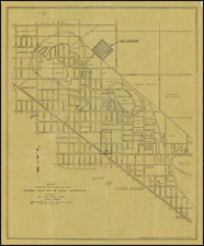
A High Class Subdivision For Bungalows
Interesting subdvisions map promoting the sale of Single Family Residential lots of the neighborhood northwest of the Wilshire Country Club, published by the original developer in about 1921.
Located adjacent to the West Sixth Street Car Line (and early Los Angeles light rail line) and bounded by Melrose Avenue, Larchmont Blvd, Rosewood Avenue and Bronson Avenue, the map shows 132 residential lots, then priced between $2,600 and $4,500. "Prices include sewer, water, gas, electricity, cement sidewalks and curbs, oiled and graveled streets." The map comes with a price list "Effective December 10th, 1921," and a business card and discount schedule slip.
Curiously, the map refers to restrictions on the lots which expire January 1, 1950. However, the map is definitely from about 1921, as the broker names listed at the bottom were active in a short window of time between about 1920 and 1922.
The present map is marked with lot sales, in red and blue, likely by an early real estate broker.
Rarity
We were unable to locate another example of this map.
![[ Los Angeles, Santa Barbara, and Monterey ]. Plans on the Coast of California](https://storage.googleapis.com/raremaps/img/small/72683.jpg)