|
||

|

|
|

|
Stock# 92529
Description
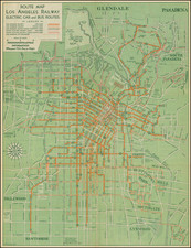
Hand Annoted by the Automobile Club For An Early Tourist!
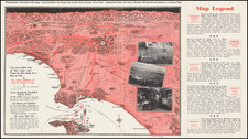
Detailed map of the Los Angeles Metropolitan Road System, compiled and distributed by the Automobile Club of Southern California.
Of note on the present example are the annotations in red crayon, which were almost certainly added by an early Automobile Club employee, illustrating the route from the Automobile Club office at the corner of Adams and Figueroa in downtown Los Angeles to Long Beach, with several tourist attractions (Beverly Hills, Hollywood Bowl and San Fernando Mission) circled in red.
The map provides a detailed overview of the Los Angeles Basin with an inset of the "Congested District."
Condition Description
Minor soiling. Several notes added in red crayon.