|
||

|

|
|

|
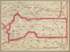
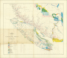
Early Mapping of the Southern California Metropolitan Region Crossed by the San Andreas Fault
Scarce geological map centered on San Bernardino and the Inland Empire, published by the State of California.
The map was issued in the same year as the 1934 Parkfield Earthquake, the second major event along the San Andreas Fault after it was first discovered by UC Berkeley geology professor Andrew Lawson in 1895 and determined to extend all the way to Southern California, following the San Francisco Earthquake of 1906.
The map extends from the San Gabriel and San Bernardino Mountains in the north to Lake Elsinore in the far south. The cities of Corona, San Bernardino, Redlands, and Pomona are shown. Twenty strata dating mainly to the cretaceous and younger periods are shown, reflecting the relatively recent activity of deposition and volcanisms in this area. A pre-Cretaceous basement is also labelled.
Faults, synclines, and anticlines are all shown, including most notably, the path of the San Andreas Fault from the Cajon Pass in the North and along the northern boundary of San Bernardino, Redlands and Yucaipa, on toward the Imperial Valley. Two other prominent faults in the region are the right-lateral Chino Fault, which uplifts the Chino Hills to the west and has the potential to cause a Mw 6-7 event, and the Cucamonga Thrust, which contributes to the uplift and rotation of the San Gabriel Mountains in the north, which has a similar earthquake-generating potential. These both act as geological boundaries between older basement rocks and more newly deposited sediments.
This area is particularly prone to earthquakes due to its proximity to the "Big Bend" of the San Andreas Fault, in which a deflection of the strike of this continental boundary due expansion of the Basin and Range Province requires the partitioning of regional compression among several rotating faults in this area. Thrust faults such as the Cucamonga Fault gradually rotate, creating east-west striking mountain chains while also allow for some regional extension. Since this area is so active tectonically, new basins are being constantly created, which contributes to the youth of sediment seen in the area.
The map is part of California's modern history investigating its geology, including the fault lines which criss-cross the state. To put this map into context, it was printed 2 decades before geologists Mason Hill and Thomas Dibblee first proposed large-scale (hundreds of miles) lateral movements along the San Andreas Fault. Considered radical at the time, the theory has since been validated by modern plate tectonics.
One of the earliest printed maps of the area to focus on tectonic features.