


|
||

|

|
|

|
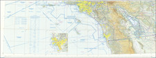
Vintage brochure featuring a pictorial map of California and Nevada, alongside small route maps of the Bay Area and Los Angeles, issued by Union Oil Company of California. Colorful illustrations show many sites: La Jolla Caves, movie studios and Griffith Observatory in Los Angeles, the Rose Bowl, Santa Cruz Beach, Chinatown and Golden Gate Park in San Francisco, parks and missions throughout the region, and more. Places of interest and events in the two states are enumerated, including the Nevada State Fair held at the time in Fallon.
The verso has a road map of California and Nevada underneath the National Safety Council's, "Be Careful! The life you save may be your own!" slogan; Triton premium motor oil cans anchor the border's four corners.
Rand McNally & Co. is a large American map and navigation company best known for its annual atlases. The company got its start in 1856, when William Rand opened a print shop in Chicago. He was joined in 1858 by a new employee, Andrew McNally. Together, the men established their namesake company in 1868. Originally, the company was intended to print the tickets and timetables for the trains running to and through Chicago; their first railway guide was published in 1869.
By 1870, they had shifted from just printing to publishing directories, travel guides, and newspapers. Their first map appeared in 1872 in a railway guide. The map was produced using a new wax engraving method, a cheaper process that gave the company an edge.
By 1880 Rand McNally had entered the education market with globes, wall maps, and geography texts for students. In 1923, Rand McNally published the first Goode’s World Atlas, named after its editor, Dr. J. Paul Goode. For generations afterward, this would be the standard classroom atlas.
In 1899, William Rand left the company, but McNally and his family remained, controlling the company for over a century. In 1904, they published their first road map intended for automobiles and by 1907 were publishing Photo-Auto Guides, which combined photography and mapping to help drivers. In 1924, they produced the Auto Chum, a precursor to their famous road atlases. Rand McNally would remain the leader in road maps and atlases throughout the twentieth century.
In 1937, Rand McNally opened its first store in New York City. Ever on the frontier of technology, Rand McNally pioneered the scribing process for printing tickets in 1958 and printed their first full-color road atlas in 1960. Arthur Robinson developed his now-famous projection of Rand McNally in 1969. By the 1980s, the company was exploring digital reproduction and digital databases of maps for truckers. In the 1990s, they lead the charge to develop trip-planning software and websites. Today, most of its products are available online or in a digital format, including maps for tablets and phones.
![[ Mount Vernon ] The Kitchen Garden of Mount Vernon, Seat of General George Washington in Viginia, The Design of an Elegant Kitchen and Fruit Garden Containing 0.92 Acres](https://storage.googleapis.com/raremaps/img/small/101604.jpg)
![[Texas Centennial Exposition]](https://storage.googleapis.com/raremaps/img/small/76381.jpg)