|
||

|

|
|

|
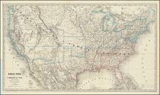
Western Exploration and Other Military Movements in 1858
Scarce map of the United States, showing U.S. Army troop movements throughout the United States by land and sea in the preceding year.
The map illustrates US Army exploration in 1858, primarily in the Transmississippi West.
The majority of action is focused in Texas, the Plains and the Rocky Mountains, with some surveys tracking along the West Coast between Walla Walla and Ft. Dalles to Southern California. A number of Western forts are located.
Wheat notes:
. . . [Shows] considerable activity on the part of the troops. From Omaha to Salt Lake City and from Fort Leavenworth to Bent’s Fort and beyond, and throughout Texas the lines representing lines of march go. An interesting such line running from Fort Bridger across country to Fort Massachusetts represents the march of Marcy and a detail of men from General Johnston’s army (which was proceeding toward Salt Lake City) to secure supplies, which occurred in the extreme weather of the middle of winter. Just how they escaped freezing in the snows of the Rockies is still hard to explain. . .
Rarity
The map is scarce. This is the second example we have ever offered for sale.
![[The Russian Question] Die Russische Frage. Ein Schauspiel von K. Simonow](https://storage.googleapis.com/raremaps/img/small/83978.jpg)