|
||

|

|
|

|
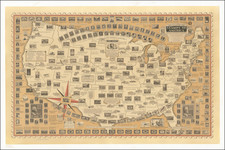
Attractive vintage airline map of the United States, showing the routes flown by United Airlines. Printed on two sides, one side of the piece shows the western United States while the other shows the eastern part of the country. Numerous air routes are shown, demonstrating the extent of United Airlines' reach in the late 1950s.
Curiously, no route has yet reached Florida at the time of this map's creation. However, Hawaii is well-serviced, with many Hawaiian Airlines flights between the islands and flights to Los Angeles and San Francisco. Extra cartoon images show views from Hawaii to San Francisco and New York. The map advertises that "The entire United fleet is Radar-equipped," and the five different aircraft flown by United Airlines at the time are named.
![[United States] Index Map](https://storage.googleapis.com/raremaps/img/small/67626.jpg)
![[ Wyoming Attached To Dakota Territory ] The United States of America](https://storage.googleapis.com/raremaps/img/small/99363.jpg)