|
||

|

|
|

|
Rare George M. Wheeler Topographical and Land Classification Atlas Sheets volume for the 1878, with 9 (of 10) maps on 8 sheets, possibly as issued in this format.
These separate atlas sheet volumes are rare to find from Wheeler, largely due to the inconsistent nature of the publication of the Survey's findings. The maps are sometimes encountered in composite atlas volumes or separately.
Apparently, these octavo volumes were also issued with paper board covers with the title printed in black.
The front pastedown gives a list of the maps and brief descriptions:
NOTE.
The topographical atlas sheets, ten in number, herewith enclosed, issued during the fiscal year ending June 30, 1878, accompany additional Annual for 1878 of Lieut. George M. Wheeler, Corps of Engineers, in charge of United States Geographical Surveys, and are in continuation of the series embracing the territory of the United States lying west of the 100th meridian (see Progress Map). Upon several of the above sheets as a basis the divisions of the land separated into agricultural, non-agricultural or arid, mineral, &c., are shown by colors.
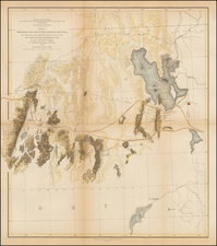
1. Sheet No. 41 B. Southeast corner of Idaho and part of Northern Utah, including Bear Lake and a portion of Bear River drainage, and lying mostly in the Great Salt Lake Basin. Area, 4,075 square miles, or 2,608,000 square acres; scale, 1 inch to 4 miles, or 1:253440.
2 and 3. Sheet Nos. 47 B and 47 D (double sheet). Parts of Eastern California and Western and Southwestern Nevada, including portions of the American Fork and Yuba Rivers, Carson and Truckee Rivers, Tahoe, Pyramid, and Honey Lakes, and a portion of the Sierras, through which the Central Pacific Railroad passes. Area, 8,406 square miles, or 5,379,840 square acres; scale, 1 inch to 4 miles, or 1:253440. (In skeleton only.)
4. Sheet No. 61 A. Part of Western Middle Colorado, immediately west of the Continental Divide, including the Gunnison, West Elk, Marcellina, and other Rocky Mountain peaks, parts of the drainage basins of the Gunnison and Uncompahgre Rivers, and the Los Pinos Indian Agency. Area 4,278 square miles, or 2,737,920 square acres, scale, 1 inch to 4 miles, or 1:253440.
5. Sheet No. 61 C. Part of Southwestern Colorado, including the basins of a number of tributaries of the Gunnison River from the south, and the headwaters of the Rio Grande and of a number of streams flowing into the San Juan. The Continental Divide traverses the southeastern and eastern parts of the sheet in horseshoe form. The greater portion of the San Juan Mining District is embraced. Area, 4,326 square miles, or 2,768,640 square acres; scale, 1 inch to 4 miles, or 1:253440.
6. Sheet No. 62 A. Part of Central Colorado, including portions of the Arkansas Valley from the vicinity of Pueblo to the westward, and bordering on the Plains. Pike's Peak appears near the northern limit of the sheet, and the "Fontaine qui bouille," rising near, joins the Arkansas, in its course, at Pueblo. Area, 4,278 square miles, or 2,737.920 square acres; scale, 1 inch to 4 miles, or 1:253440.
7. Sheet 62 C. Part of Central Colorado, including the drainage of a number of creeks reaching the Arkansas from the 7- Sheet south, the Sangre de Cristo Mountains, and other ridges dividing the Arkansas from the San Luis Valley. Area, 4,326 square miles, or 2,768,640 square acres; scale, 1 inch to 4 miles, or 1:253440.
8. Sheet No. 69 D. Part of Northern Central New Mexico, including portions of the Rio Grande Basin and a number of creeks entering from the eastward to the south as far as Santa Fé, N. Mex., and also the Chama River, a western affluent. Area, 4,420 square miles, or 2,828,800 square acres; scale, 1 inch to 4 miles, or 1:2:3440.
9. Sheet No. 77 D. Part of Central New Mexico, including a portion of the Rio Grande Valley, and mountain ridges to the eastward south of Albuquerque, N. Mex. Area, 4,510 square miles, or 2,886,400 square acres; scale, 1 inch to 4 miles, or 1:253440.
10. Sheet No. 84 B. Part of Central New Mexico, including a part of the drainage basin of the Pecos in the eastern and of the Rio Grande in the northwestern portion; also the northern of the San Andreas Mountains, several minor mountain reason of the Jornada barren plain, a peculiarly marked lava flow castes, and Fort Stanton. Area, 4,554 square miles, or 2,914,560 square acres; scale, 1 inch to 4 miles, or 1:253440. (In skeleton, showing hachuring in part only.)
Complete or Incomplete?
This set has 9 of the 10 maps called for on the contents pastedown, giving rise to the conclusion that the volume is incomplete. However, this is probably not the case. The table of contents has a very formal crossing-out of the fourth map, 61 A. This redaction is seen in more than just this example. Indeed, the last copy to sell at auction (Heritage, 2016) lacked the same map with a similar explanation being provided. There may be later issues of the volume, which were completed after the completion of the map, that include all 10 maps.
![[Seattle's First Zoning Ordinance] Zoning Ordinance of the City of Seattle Effective July 27, 1923](https://storage.googleapis.com/raremaps/img/small/69390.jpg)
![[ World Atlas ] Allgemeiner Hand Atlas Der Ganzen Erde nach den best atronomischen Bestimungen, neuseten Entdeckungen und kritischen Unterluchungen entworfen](https://storage.googleapis.com/raremaps/img/small/102647.jpg)