


|
||

|

|
|

|
Stock# 49277
Description
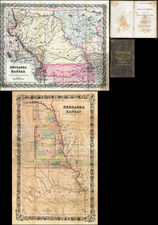
A detailed map showing the Great Salt Lake, Utah Lake and Sevier Lake, with the Humboldt Mountains at left edge.
Includes the region from the Great Salt Lake and across the flats to the Humboldt range. Several proposed railroad routes noted, including one earlier surveyed in 1854 through the To-a-no Mountains.
Very good depiction of the Emigrant Road skirting north of the lake.
Wheat considers this an excellent map "due in large part to Egloffstein's work as Topographer for the Route."
Condition Description
Minor toning at folds.
Reference
Wheat #823.

![Karte von Tejas und den angrenzenden Theilen Mejicos . . . [with California Gold Regions Inset]](https://storage.googleapis.com/raremaps/img/small/61669.jpg)
![[DeWitt Clinton Copy] An Account of Expeditions to the Sources of the Mississippi, and through the Western Parts of Louisiana, to the Sources of the Arkansaw, Kans, La Platte, and Pierre Jaun, Rivers During the years 1805, 1806 and 1807. And a Tour through the Interior Parts of New Spain. in the year 1807.](https://storage.googleapis.com/raremaps/img/small/81745.jpg)
![(Mexican War) [ Proposed United States - Mexico Military Border - January 1848 ]](https://storage.googleapis.com/raremaps/img/small/99246.jpg)