


|
||

|

|
|

|
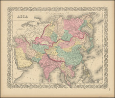
Fine enlarged example of renowned French geographer Jean Janvier's map of Asia, published in Venice around 1780.
The map offers a fascinating depiction of continental Asia and its outlying islands. The "Mer de Coree," or Sea of Korea, is named explicitly, indicative of the region's growing significance in global commerce and politics.
Significantly, the Torres Strait, which separates Australia and New Guinea, is absent from the map. Instead, "Carpenterie" (referring to Cape York Peninsula in Australia) is shown as connected to New Guinea. This absence underscores the limitations of eighteenth-century exploration, with the Torres Strait not being confirmed until 1770 by the British navigator, Captain James Cook. At the time of Janvier's map, the vast expanses of the Pacific were still a mixture of verifiable fact and tantalizing conjecture.
This blend of fact and fiction is further exhibited in the depiction of the Philippine Islands, their contours strangely distorted, reflecting the incomplete and often erroneous data that early explorers provided. Similarly, the inclusion of the mythical "Terre de la Compagnie" south of Kamchatka points to the persistence of imaginative geography and the thirst for further exploration in the uncharted regions of the Pacific.
One of the most intriguing features of the map is the mention of the "terre vue par Mr.s Tchiricow et Delisle en 1741," or "land seen by Mr.s Tchirikow and Delisle in 1741". This inscription references Aleksei Chirikov, a Russian mariner who, along with Vitus Bering, led the Second Kamchatka Expedition initiated by the Russian Czar Peter the Great. Chirikov's discoveries, including the sighting of landmasses in the North Pacific, notably the Aleutian Islands and possibly the Alaskan mainland, were later incorporated into the maps of Joseph Nicolas De L'Isle, a French geographer working for the Russian Czar. The delicate balancing act between the practicalities of statecraft and the pursuit of knowledge is keenly evident in these representations, adding yet another layer to the intricate tapestry of Janvier's map.
A striking feature of the map is the notation regarding its projection method. In English, the French inscription translates to, "The projection of this map does not allow for a general scale that can be used to measure all parts, one will use the latitudes which are drawn every 5 degrees which are worth 20 Marine Leagues or 25. common Leagues of France." This notation illustrates the limitations inherent in the cartographic techniques of the era, where the precise portrayal of vast geographical expanses posed considerable challenges.
Paolo Santini (1729-1793) was an Venetian engraver known especially for his religious prints and fine cartographic engravings. He published in Venice and may have a been a member of the clergy. In his maps, he largely adopted and adapted the work of his French counterparts, especially the brothers de Vaugondy.
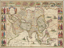
![[6 Sheet Wall Map of Asia] L'Asie divisee suivant l'Estendue de ses Principales Parties dans lesquelles sont distinguees les unes de autres Les Empires, Monarchies, Estats et Principaux Peuples qui partagent a present L'Asie . . . 1719](https://storage.googleapis.com/raremaps/img/small/80841.jpg)
![[Spectacular Set of Wall Maps of the Continents Dedicated to King Charles II of England, &c.]](https://storage.googleapis.com/raremaps/img/small/93614.jpg)