|
||

|

|
|

|
The Height of Dutch Decorative Cartography -- Heightened in Gold and Lapis Lazuli
One of Only Two Complete Sets in the World (the other at the Swedish National Library).
The Only Set in the First State.
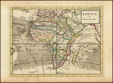
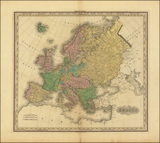
A spectacular set of wall maps of the continents (Europe, Asia, Africa, and the Americas), published at the apex of Dutch decorative cartography by two of the most important mapmakers of the era, Nicolaes Visscher II and Hugo Allard.
In the pantheon of European wall maps published between the end of the 16th century and the beginning of the 18th century (when this art truly flourished), this set stands out for its extraordinarily elaborate engraved decorations: each map is imposingly embellished with piles of figures - representations of local flora and fauna, and of local peoples, of allegorical vignettes, and of scenes of trade and conquest.
These maps are also unique among Dutch wall maps for their focus on the English-speaking world; the set is dedicated in English to Charles II, with his portrait and inscription on the map of Europe. Furthermore, an elaborate cartouche on the map of Asia centers the coat of arms of Charles II, perhaps indicating the ascendancy of the East India Company.
Any one of these maps individually would be the cornerstone of a collection, but here we have only the second complete set of the four maps anywhere in the world. Intriguingly, while this set comes from Ericsberg Palace in Sweden, the other known set is at the Swedish National Library, a short distance away in Stockholm. Moreover, the two sets are both lavishly colored, heightened in gold and finished with Lapis Lazuli. Links to the individual maps in high resolution can be found here:
- America / Exacta Totius Americae Tabula
- Asia / Exacta Totius Asiae Tabula
- Europe / Exacta Totius Europae Tabula
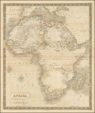
- Africa / Exacta Totius Africae Tabula
The maker of the maps, Nicolaes Visscher II (1649-1702), came from one of the all-time most important mapmaking families in the Netherlands. His grandfather, Claesz Jansz. Visscher (1587-1652), was a foundational early mapmaker and engraver of the Dutch Golden Age, and Nicolaes's father, Nicolaes Visscher I (1618-1679), continued that tradition. Nicolaes Visscher II focused first and foremost on the opulence of his cartographic creations; in addition to these wall maps, he was responsible for one of the greatest Dutch atlases ever produced, the 226-map Atlas Minor.
Visscher used the standbys of second-half-of-the-17th-century Dutch wall maps for the cartography. In Africa and Europe, he closely follows Joan Blaeu's 1659 wall maps (Novissima Africæ Descriptio and Europæ Nova Descriptio, respectively). Burden (555) notes that the Americas closely follows De Wit's wall map of 1672. There may be no direct antecedent for the map of Asia; the inset of Australia is unusual, and we can find no other wall map in which this has been done. In that case, the map could be an original compilation based on sources such as Blaeu's 1659 Asia and his wall maps of Australia and Southeast Asia.
A Note on Dating and States
The maps were, from the outset, intended as a set, with a remarkable dedication to Charles II, the King of England, which is found on the map of Europe:
To The Most Illustrious and Puissant Monarch, Charles the II, By the Grace of God of England, Scotland, France and Ireland King Defender of the Faith &c. This Geographical and Hydrographical Map of Europe Together with three other Parts of the World, to wit Asia, Africa, and America, composed with great Experience and Labour, is with all Submission Dedicated, By His Majesties most humble and obedient Vassal. Nic. Visscher.
These maps have traditionally been dated 1682-1685 in the literature (Betz and Burden). To this, we can offer a few minor corrections:
The set in Stockholm (KB) on which previous studies have been based should be dated to 1688 or later, as the map of Europe has been revised with a portrait and dedication to William III, and the map of Asia has been updated with his coat of arms. Thus the present set represents the maps in their first state (with dedication and iconography of Charles II, who died in 1685.)
We also propose that the maps might have been completed at the end of Nicolaes Visscher I's career, between the granting of his first privilege (July 1677) and his death in 1679. It is also plausible that this map pre-dates the earliest known privilege.
Rarity
This is the only known example of the first state of this set, which was unknown to scholars until it was offered for sale at the Ericsberg Palace Sale II, in June 2022.
There is 1 known set of the second state (Swedish National Library), with revised portrait on the map of Europe (William III) and revised English Coat of arms on map of Asia.
We locate a single example of the map of Europe (state 1), lacking the decorative panels (Bibliotheque National de France)
Individual examples of the map of America are known to survive in the Bibliotheque National de France (lacking decorative panels) and a private American collection (for decorative panels).
Individual examples of the map of Africa are known to survive in the Bibliotheque National de France and a German National Library (each lacking decorative panels).
Provenance
Ericsberg Palace, Katrineholm Municipality, Södermanland County, Sweden.
Hugo (or Huych) Allard (or Allardt) (1627–1684 or '91) was a draughtsman, engraver, and painter during the Dutch Golden Age of cartography. Based in Tournai and Amsterdam, he was the founder of a prominent family of Dutch mapmakers, publishers, and print sellers. Allard set up his cartography business around 1645, and his first works were mostly reissues of earlier maps. Although not as prominent as the Blaeu family or Henricus Hondius and Jan Janssonius, Hugo Allard’s work, from about 1640 to 1680, is considered to be just as fine in quality. His output was relatively small, and his maps were mostly published as loose, separate issues, but they were well-designed and finely engraved. After Allard’s death, he left his business to his son, Carel. There is some confusion about when he died; some sources state 1684, others say 1691.
Nicolaas Visscher II (1649-1702) was a prominent Dutch cartographer and publisher during the late 17th century. He was the grandson of Claes Janszoon Visscher and the son of Nicolaes Visscher I, both of whom were also renowned cartographers in their own right. After his father's death in 1679, Nicolaas Visscher II took over the family's map publishing business.
In 1680, he married Elizabeth Verseyl from Gouda, and in 1682, he obtained a new privilege from the States of Holland and West Friesland to protect his maps and publications from being copied. Visscher II continued the family tradition of producing high-quality maps, atlases, and globes, often with elaborate and decorative elements. He maintained the Visscher family's reputation for accuracy and craftsmanship in the competitive world of Dutch cartography until his death in 1702. After his death, his widow, Elizabeth, and later his son, also named Nicolaas, continued the business until around 1726.