|
||

|

|
|

|
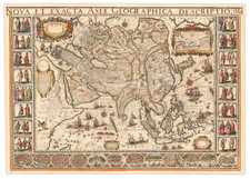
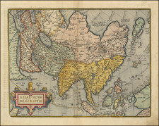
Rare six-sheet wall map of Asia, published in Paris by Alexis-Hubert Jaillot in 1719.
Fine example of the first state of AH Jaillot's rare wall map.
While at first glance the map appears to be an enlarged example of Jaillot's 2 sheet map of Asia first issued in the 1670s, the present map provides a significantly more detailed treatment of the region, with more place names and cartographic detail. It is also a significant improvement from the 1719 edition of Jaillot's 2 sheet map: https://www.raremaps.com/gallery/detail/79701. The map provides updated cartographic detail in a number of regions, as outlined below:
Gulf / Middle East
In the Gulf region, the number of place names on the southern coast of the Golfe de Bassora ou d'Elcatif has nearly tripled, drawing heavily upon Sanson's map of the region. The name Biscia is shown. This would seem to be an early printed appearance of the name "Bishita," a name which dates back to the 8th and 9th Centuries, when it appeared in Eastern Syriatic documents of the Old Testament, "referencing the prosperity of the 'Bayt Qatarya' region." (see, Khalid Al-Jaber, Media In Qatar, Katara (Publishin House 2021), p. 23)
Australia
The map adds the words Nouvelle Holland and shows a meaningful treatment of the Northern Coastline of Australia, significantly updated from the simple depiction of Carpenteria on the 2 sheet map.
Korea
The Korean Peninsula is now shown much wider, with additional place names and rivers.
Southeast Asia
Singapore (Sincapura is named). Significantly more topographical detail and place names are shown. The Kingdom of Laos is shown (rather than Layes)
The title across the top is L'Asie Distinguee Suivant L'Estendue De Ses Principales Parties.
Rarity
The map is apparently very rare. We were unable to locate another example of the first state of this map offered for sale at auction or in a dealer catalog.
We note a single example in the Bibliotheque National De France, which is also catalogued as dated 1695, but there seems to be no image of a 1695 edition: https://gallica.bnf.fr/ark:/12148/btv1b55013159h
The Bibliotheque National De France holds a modified example of the map dated 1782 / 1789, published by Desnos: https://gallica.bnf.fr/ark:/12148/btv1b530298664.
We note examples of this map offered by the Librarie Le-Bail Weissert in 2003 and at auction in 2008.
Alexis-Hubert Jaillot (ca. 1632-1712) was one of the most important French cartographers of the seventeenth century. Jaillot traveled to Paris with his brother, Simon, in 1657, hoping to take advantage of Louis XIV's call to the artists and scientists of France to settle and work in Paris. Originally a sculptor, he married the daughter of Nicholas Berey, Jeanne Berey, in 1664, and went into partnership with Nicholas Sanson's sons. Beginning in 1669, he re-engraved and often enlarged many of Sanson's maps, filling in the gap left by the destruction of the Blaeu's printing establishment in 1672.
![(Rare copperplate edition!) Asia Secunda Pars Terrae in Forma Pegasi [Asia in the Form of Pegasus]](https://storage.googleapis.com/raremaps/img/small/82046.jpg)