|
||

|

|
|

|
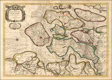
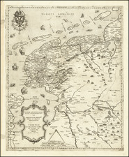
Tracking the Spanish and Dutch Armies along the Ijsell River in the Summer of 1606
Rare separately published Dutch broadside, showing the military actions in the area of the Ijssel River in Overijsesel and Gelderland in July and August 1606.
The map is oriented with west at the top and shows positions of Spanish and Dutch troops in 1606, during the Eighty Years War. The map tracks the movements of the the Spanish Army of Flanders (under Abrosio Spinola) and Dutch Forces (under Maurice of Nassau), showing Spinola's attack of the Zutphen region. Larger towns include Zutphen, Deventer, Arnhem, Zwolle, Groenlo, and Coevorden.
Title in French below is: Contrefaicture du Fleuve Isel, del la Diocese Trans Isulane, & Conte de Zutphen. Legend locates 15 points of interest.
The map was printed by Baptista van Doetecum. After a famed career as an engraver Amsterdam, Van Doetecum moved to Deventer as a "boeckdrucker ende plaetsnysder" and on February 16, 1606 he was granted a patent to print books, almanacs and similar material. This map
Rarity
The map is extremely rare. We note an example at the Rijksmuseum and Bibliotheque National de France.
An example of the map is also referenced as item 1235 in an 1870 Frederick Muller catalog entitled 100 B.C.-1702 A.D.
Provenance: Binoche-Renaud-Giquello, November 9, 2007, Item 139.