


|
||

|

|
|

|
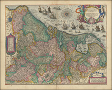
First stat of this important early map of Friesland, based upon Jacob van Deventer's map of 1545.
Camoccio's map is the was issued shortly after the map of Roman mapmaker, Michele Tramezzino, which in turn was the earliest surviving map based upon Jacob van Deventer's 6 sheet map of Friesland. From historical sources it is known that van Deventer spent some time in Friesland between 1544 and 1545, during which time he created the first modern map of the region.
The first definitivley known printed edition of the map was made in Antwerp in 1559: a large version in six sheets, by Bernard van den Putte. It is possible that this may be the reprint of the mysterious Van Deventer of 1545. The map survived in 1 example in the Wroclaw library, until it was destroyed during the Second World War.
The first surviving derivation of van Deventer's work is one of the small maps on a single sheet with text, which appeared Sebastian Münster's Cosmographia (Basel 1550).
Woodward attributes the engraving to of the CIncludes the coat of arms of Charles V, top left. Decorated with numerous ships and sea monsters.
Camoccio map to Paolo Forlani, based in part on the fact that both Bagrow and Van't Hoff cite an example with the imprint of Pauli Forlani Veronensis, for which Bifolco was unable to trace any surviving examples. A second state with the name of the publisher partially removed and the date M.D.LXVII is mentioned by Almagià and then by Meurer, but Bifolco was unable to find any surviving examples.
States of the Map
- State 1: FRANCISCI CAMOTII FORMIS AD SIGNUM PIRAMIDIS M.D.LXVI imprint
- State 2: Abraded the signature of Camocio, change the date to M.D.LXVII.
- State 3: Dated M.D.LXXXXI. Imprint added: Apud Donatum Bertellum (one known example).
![[ Amsterdam ] Accurater Grundris und Prospect der Weltberuhmten Hollandischen Haupt und Handels-Stadt Amsterdam . . . 1727](https://storage.googleapis.com/raremaps/img/small/89309.jpg)
![[Brielle] Brilium Holandiae Opp. . . .](https://storage.googleapis.com/raremaps/img/small/89292.jpg)
![[Proposed Canal / Utrecht to the Sea] Nieuwe en Nette Aftekening van de Door Gravinge die er staat te Geschieden beginnende van de Stadt Utrecht to aan Spakenborg in de Zuyder Zee met des zelfs Afbakinge &c](https://storage.googleapis.com/raremaps/img/small/94380.jpg)