|
||

|

|
|

|
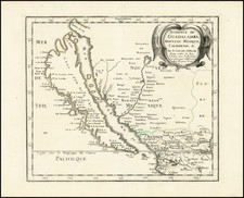
Very rare map of the Southwestern US, a remarkable early inset map of the Yosemite Valley, showing a number of landmarks along the Merced River, including the Hutching Hotel, Nevada Falls, Vernal Falls, Sentinelle, 3 Brothers, El Capitan, etc. The map of Devil's Canyon (Death Valley?) is perhaps even more fascinating, being the only map we have ever seen of this region. Names Devil's Tea Kettle, Devil's Washtub, Witches Calderon, etc. The main map, which extends from the Pacific to the Mississippi River, illustrates the course of the Union Pacific Railvoad (sp), and includes towns, mountains, rivers, Lkes, Indian Tribes, Fremont's route of 1845, a number of Western Forts, etc. A rare map, apparently issued to promote travel to California. The first example we have ever seen. Wide margins. Folded, as issued. A marvelous opportunity to buy a rare Yosemite item. If you can tell us where Devil's Canyon is, we'd be delighted to know!
![[Northern California] North Bay Horse Country](https://storage.googleapis.com/raremaps/img/small/86802.jpg)
![Air Log Western Air Express [Los Angeles-San Diego, Las Vegas-Los Angeles, Milford-Vegas, Salt Lake City-Milford]](https://storage.googleapis.com/raremaps/img/small/85953.jpg)