


|
||

|

|
|

|
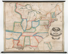
First Appearance of Austin's Settlement In Texas
Nice example of the 1830 edition of Amos Lay's wall map of the United States, first published in May of 1827, the earliest obtainable printed map to include Austin's Settlement and the earliest map of the United States to emphasize Indian Settlements a distinct geographical regions.
Lay's map is unique in that it shows a blue outline coloring for the major Sovereign Indian regions of the United States, including those in Missouri, Georgia, Mississippi, Alabama and Arkansas. The reservations are also delineated in Michigan, Illinois, and Indiana, but without blue color.
Carver's Indian Grant is noted in North West Territory, with a massive Missouri Territory to the west , crossed only by the "Route of the Traders from Missouri to New Mexico." Further West in Arkansas Territory, Stephen Long's route to the Rocky Mountains along the South Fork is shown.
Streeter noted that the 1827 edition of the map is the earliest appearance of Austin's Settlement on a printed map, with the exception of a rare Mexico City imprint (the Galli Map), known in only one example. Streeter notes that the settlement, likely intended to be San Felipe de Austin, is incorrectly shown on the east bank of the Colorado River. The mythical Presidio of Nacogdoches is shown, not far from the coast between Galveston Bay and the Sabine River. St. Louis Bay is shown at the mouth of the Brazos.
Includes a large inset map of Florida, including the route of a proposed Atlantic to Gulf Coast canal from Pilatkia, south of St. Augustine on the St. Mary's River to the Tampa River and Espiritu Santo Bay, which was not present in the 1827 edition of the map and first appears in the 1829 edition.
States of the Map
Streeter notes the existence of the 1827 and 1830 edition To this, we can add an 1829 edition, which we handled in 2015, and an 1832 edition.
We note the following changes between the present 1830 edition and the 1829 edition:
- An additional road system has been added in Texas, linking Galveston Bay with Nacogdoches and the "Coshatta Indians" east of the Sabine River.
- The counties and Indian lands in Arkansas have been substantially reconfigured, with new allotments for the Osage, Kickapoos, Delawares, and Shawnees. Reflecting the early Trail of Tears resettlements
Rarity
The Lay map is scarce on the market.
![Le Colonie Unite Dell' America Settentrle. Di Nuova Projezione a S.S.E.E. Li Signori Riformatori Dello Studio Di Padovia . . . 1778 [12 sheets]](https://storage.googleapis.com/raremaps/img/small/90539.jpg)


![(Republic of Texas Land Grants with Maps - Coahuila y Tejas) [Manuscript land grant documents issued by Radford Berry, alcalde of Nacogdoches, to John Adams and others, with manuscript plat maps by Arthur Hendrie and George Aldrich]](https://storage.googleapis.com/raremaps/img/small/88920.jpg)
![[First Map of the Mississippi River] Carte de la decouverte faite l'an dans l'Amerique Septentrionale](https://storage.googleapis.com/raremaps/img/small/93571.jpg)