


|
||

|

|
|

|
Early Texas Land Grant Documents
With Manuscript Plat Maps by Pioneer Texas Land Surveyors, Arthur Henrie and George Aldrich
With Three Examples of an Early Pre-Republic of Texas Seal Design
A group of original Spanish-language land grant documents issued in Nacogdoches, Texas, ca. 1836-1838. With plat maps drawn by two pioneering Texas surveyors, Arthur Henrie and George Aldrich.
Radford Berry was acting as "constitutional alcalde" of Nacogdoches at the time of these documents. In 1835 President Santa Anna had revoked the Mexican Constitution of 1824, abolishing all state governments. American settlers in Texas began to revolt against the Mexican central government in what would become known as the Texas Revolution. By April 1836, Texas had become the independent Republic of Texas.
The documents are as follows:
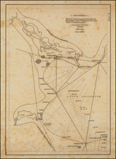
- Spanish language land grant issued in Nacogdoches, Nov. 6, 1837, with two-sheet manuscript plat map by surveyor Arthur Henrie, showing "Un Sitio de Tierra de la pertenencia del Ciudadano John Adams." With English-language certification by the Houston County clerk, docketed on verso of outer sheet: "Received for record, November 6th 1837, D. Lacey." 8 pages. Partial transcription:
- Señor Comisionado Especial de la Empresa del Ciudadano David G. Burnet. John Adams natural de los Estados Unidos del Norte con el devido respeto ante V. me presento y digo: Que atraido por los generosas disposiciones de los leyes de colonizacion de este Estado, he venido con mi familia constando de tres personas á radicarme en el si en vista de la adjunta certificacion V. tuviere á bien admitirme en clase de colono concediendome la cantidad de tierra que me corresponde en los valdios de la referida empresa, de cuyo favor vivere enteramente agredecido, John Adams, Nacogdoches, Septiembre diez y siete de mil ochocientos treinta y cinco...In the Town of Nacogdoches this 6th day of November 1837. Personally came before me Daniel Lacey, clerk of the County Court of said County [of Nacogdoches], the above signed Jorge Antonio Nixon and acknoledged the foregoing instrument to be his act and deed... [docketed:] Received for record, July the 24th 1838. Jacob Allbright.
- English language grant on papel sellado, with early Texas seal. Nacogdoches, July 1836. With 3 x 3 inch plat map by George Aldrich, "Un sitio de tierra del ciudadano Joshua Fulcher." 2 pages, with attached notarized sheet signed in March 1838. Partial transcription:
- Know all men by these presents that I, Joshua Fulcher have this day bargained, sold, and delivered certain leagues of land laying between the Sabine and Red Rivers about twenty miles South of Lake Loda which was granted to me on the 21st of November eighteen hundred & thirty five by the Comr. Geo. W. Smith as may be seen by the accompanying title...With sheet of papel sellado with early [Signed by Radford Berry and Joshua Fulcher].
- Spanish language land sale document (fragment) on papel sellado with early Texas seal. Domingo Gonzalez of San Antonio de Bejar sells a tract of land to one Doña Elena Sanchez. Mentions neighboring lands owned by Italian-born Texas pioneer Vicente Micheli (c.1755-1848), who settled in the Spanish Territory of Texas by 1793, first in Nacogdoches (Micheli's grant was the first patented by the Spanish Crown in what became Angelina County. Micheli acquired more than 24,000 acres from a member of the Bidais tribe in exchange for some clothing and trinkets). Docketed in English on verso: "Received for Record March 28th, 1838, R. Parmalee." 1 sheet ([2] pages). Partial transcription:
- Sepone como yo Dn. Domingo Gonzalez natural de San Antonio de Bejar y becino de este, he bendido a Doña Elena Sanchez un soler de mi propriedad con 20 baras de poniente a oriente y siento de Norte estan lindados por el oriente con el arollo de la la Mision, por el Norte con la tierra verlenya y por el sur y poniente con tierra de Don Vicente Micheli, segun apareze el de ... de 26 de Mayo de mil ocho sientos diez cuya benta le ago en el balor de quince pesos, libres de todo grabamen, quedando Igualmente en poder de Da. Elena Sanchez el decreto que arriba se cita, el auto firmado y testimoniado por Dn. Manuel Salcedo, gobernador del estado de Texas en aquel tiempo... teniendo este simple documento toda la fuerza que el.. se requiere confuerza ...en Nacogdoches a los 18 dias del mes de Enero de 1835....
- Grant for the lot of Bayon Mission to Domingo Gonzalez [docket title]. Folio sheets. 8 pages of manuscript text, entirely in Spanish. A circa 1830s holograph copy of an 1810 land grant issued under Gov. Manuel de Salcedo. Partial transcription:
- Domingo Gonzalez, vesino de este Pueblo el tiempo de seis años á esta parte ante V.S... haviendo abierto y desmontado un pedaso de tierra a las orillas del Arroyo que llaman de la Mision a estramuros del Pueblo, cuia tierra dista de veinte y cinco varas de frente y sien varas de fondo, la que poseo y cultivo y prometo cultivar con todos los requisitos que pertenesen a un vesino y vasallo de S.M.Q.D.G....Proveyolo el Sor. Manuel de Salsedo, Tente. Coronel de Infanteria de los Reales Exersitos, Govor. Politico y Militar por S.M. de la Prova. de los Texas, Nuevas Filipinas, a los veinte y nueve dias del mes de Mayo de mil ochosientos diez...[with note:] Concuerda este testimonio con su original &c &c en el Archivo ... de donde yo Don Jose Maria Guadiana Tente. de Cavalleria y Comte. Militar y Politico de el Pueblo de Nacogdoches, lo hise sacar corregia y confrontado... de testigos instrumentales los vesinos Jose Antonio Santa Cruz, Jose Ybarbo, y Don Manuel Bustamante....
Coahuila y Texas
Coahuila y Tejas was divided into several departments, each of which was governed by a political chief. Departments were further subdivided into municipalities, which were governed by alcaldes, comparable to mayors. Each municipality also had an elected ayuntamiento, similar to a city council. Originally, all of Texas was included in the Department of Bexar, while Coahuila comprised several departments. After many protests from residents of Texas, in early 1834 the region was divided into three departments, Bexar, Brazos, and Nacogdoches.
The colony land offices in Texas were closed by the provisional government on November 13, 1835, which declared invalid any survey made after that date. The Texas Constitution of 1836 validated all Spanish and Mexican grants made in conformity with then standing laws.
The Fiscal Stamp of Coahuila and Texas
Three of the papel sellado leaves present here bear the handsome ink stamped seal of the Treasury of the State of Coahuila y Tejas - a very early and rare example of an official seal from Texas. The papel sellado was almost certainly stamped or printed locally, in the state capital of Monclova. Unlike the regular state seal for Coahuila y Tejas, which was essentially a slightly modified version of the Mexican national seal, the fiscal or treasury seal of Coahuila y Tejas is a unique design: the Mexican eagle's breast is surmounted with a large Eye of Providence within a pyramidal sunburst or halo. Two figures on either side of the eagle are almost definitely Native Americans, one with a bow and another with a quiver of arrows.
Plat Maps by Pioneer Texas Land Surveyor Arthur Henrie and George Aldrich
Arthur Henrie was the surveyor-general of David Gouverneur Burnet's colony, and engaged in land dealing in Texas for his own account.
The early era of pre-Republic surveying in Texas was truly a dangerous frontier endeavor. According to a fascinating article by Virginia H. Taylor Houston on early surveying in Texas, who includes George Aldrich in her list of early Texas surveyors:
It was nothing unusual for a surveyor to be killed by the Indians; often an entire party was murdered; and many expeditions started out never to be heard of again. Long since, the Indians had called the compass "the thing that steals the land."
Conclusion
A fascinating set of early Texas land documents, of historical interest for having been issued during the Texas Revolution, with references to several notable figures in Texas history.
Radford Berry was a pioneer resident of Nacogdoches, Texas. Berry Creek in Burleson County, Texas, is named for him.
![[ Hand Drawn Map ] Mexico, California, and Texas](https://storage.googleapis.com/raremaps/img/small/99068.jpg)

![[Florida Panhandle to Yucatan] Pas-Kaart Van de Golff van Mexico . . .](https://storage.googleapis.com/raremaps/img/small/93130.jpg)