|
||

|

|
|

|
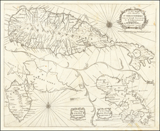
The First Dutch Map of the Lesser Antilles -- The Islands of Cannibals
Interesting map of the Lesser Antilles, published by Joannes Blaeu.
The map shows the Lesser Antilles, with west at the top of the map, extending from eastern Puerto Rico and the Virgin Islands to Trinidad and the Venezuelan coast.
Published in the form of a sea chart, the map is quite unusual for the Blaeu family, lacking the normal embellishments.
Willem Janszoon Blaeu, patriarch of the Blaeu cartographic dynasty, died in 1638. He had two sons, Cornelis (1610-1648) and Joan (1596-1673). Joan trained as a lawyer, but joined his father’s business rather than practice. After his father’s death, the brothers took over their father’s shop and Joan took on his work as hydrographer to the Dutch East India Company. Cornelis died in 1648, leaving his brother to carry on the workshop alone. Later in life, Joan would modify and greatly expand his father’s Atlas novus, eventually releasing his own masterpiece, the Atlas maior, between 1662 and 1672. The Blaeu workshop burned in 1672 and Joan died a year later.
![[ British Colonies in North America & Caribbean ] L'Amerique Angloise, ou Description des Isles et Terres du Roi d'Angleterre dans l'Amerique, Avec de nouvelles Carte de chaque Isle & Terres](https://storage.googleapis.com/raremaps/img/small/102812.jpg)
![[ English Plantations in North America ] A New Map of the most Considerable Plantations of the English In America Dedicated to His Highness William Duke of Glocester.](https://storage.googleapis.com/raremaps/img/small/98233.jpg)
![[ Curacao / Aruba / Bonaire / Venezuela ] Pas-kaart vande zee custen van Venecuela met dye Bylegende Eylanden . . .](https://storage.googleapis.com/raremaps/img/small/99928.jpg)