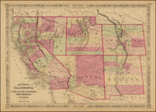
|
||

|

|
|

|
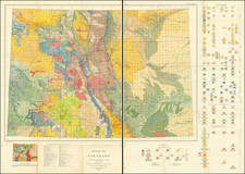
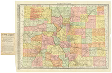
Highly detailed General Land Office map of Colorado, 5 years after it became a state in 1876.
One of the dominant features of the map are the areas shaded in red, showing Military Reservations, Indian Reservations and Private Grants.
The map shows land offices, surveyed townships railroads and land grants to the railroad lines.
Pitkin County appears for the first time (formed February 23, 1881), as does Aspen, Roaring Fork and Snow Mass. Dolores County also appears for the first time.
Some of the biggest changes occur in Southwest Colorado. The map was issued at the time the time when gold and silver were being discovered in the southwestern part of the state, in the areas around Silverton and Ouray. The towns of Telluride and Pandora appear for the first time as do Ft. Lewis and Durango in La Plata County.