|
||

|

|
|

|
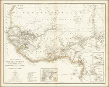
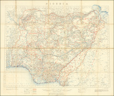
Henri Eugene Spicq's Comprehensive Map of West Africa Published by the French Ministry of Colonies
Second state of Spicq's map of a portion of West Africa, published by the Service Geographique Des Colonies and printed in Paris by Erhard Freres, first published by Andriveau Goujon in 1897.
The map provides a remarkably detailed treatment of the region, with color coding showing the French, English and German Colonies, representing a significant improvement over prior maps, most notably a comprehensive approach to the integration of data from over two dozens explorations of the region.
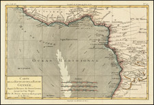
The map covers the Gold Coast, Ivory Coast and Slave Coast. At the far west is the Republic of Liberia and the Maryland Colony, along with Nigeria, Benin, Togo, Ghana Cote d'Ivoire and parts of Mali, Burkina Faso and Niger, extending north to the Timbuktu region
The title includes a list of the contributors to the contents of the map. The most remarkable feature of the map is the meticulous treatment of the Itineraires siuvis (routes taken by the various explorers identified in the title), along with a detailed accounting of local roads, railroads planned and projected, and rivers.
The map was reviewed in the Geographical Journal of the Royal Geographical Society in 1897 at page 660, noting:
This map includes all the country between the Niger and the West Coast, and is based upon the most recent surveys. The routes followed by numerous explorers, as well as those reported by the natives, are shown. The boundaries up to the date of publication are clearly defined, but in some cases they already require revision. At the present time, owing to disputes as to what nation certain portions of the territory belong, this cannot fait to be an interesting map.
This would seem to be the best and most advanced map of the region at the end of the 19th Century.
Rarity
The map is apparently very rare. OCLC locates the following examples:
- 1897 Edition: (5 examples) British Library, University of Chicago, University of Wisconsin, Milwaukee (American Geographical Society Collection), Amsterdam University, Bibliotheque National de France
- 1898 Edition: (3 examples) Paris Natural History Museum, University of Michel de Montainet Bordeaux, Bibliotheque National de France
This is the first example we have seen for sale.
![[ Nigeria ] The Central & Eastern Provinces of Southern Nigeria 1910. Compiled Under The Authority of His Excellency Sir Walter Egerton K.C.M.G. Governor and Commander-In-Chief . . .](https://storage.googleapis.com/raremaps/img/small/96351.jpg)