|
||

|

|
|

|
Charting the Slave Trade.
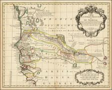
This 1753 Carte particuliere de la Coste d'Or, a sea chart of the Gold Coast of Ghana, drafted by Jacques Nicolas Bellin, France's leading maritime cartographer, reveals the grim details of European commerce, particularly the gold and slave trades, on the African coast. Published in Paris, the chart features notable European forts and extends from the Volta River in the east to Axim and Ankobra in the west, delivering a comprehensive depiction of this strategic stretch of the Gold Coast.
During the 18th century, the Gold Coast was the epicenter of two lucrative and notoriously brutal trades: gold and slaves. European powers, through their forts, exerted control over these trades, shaping the political, economic, and social landscape of the region. The chart lays bare this grim history, highlighting various forts such as Fort Fredericsbourg, Fort Vredenburgh, Cape Coast Castle, Fort Amsterdam, Fort Winneba, Fort Goede Hoop, Ussher Fort, Osu Castle, and Elmina Castle, all pivotal locations in the European exploitation of African resources and people.
This chart, part of Bellin's monumental work Hydrographie française, serves not just as a geographical representation but also as a potent artifact of maritime history. Bellin was the Premier Ingénieur of the Depot de la Marine and the Official Hydrographer of King Louis XV, posts that placed him at the center of France's maritime and colonial endeavors. His work is thus emblematic of the era's cartographic artistry and its underlying colonial dynamics.
Unusually, this example of the map includes rhumb lines not present on most versions of the chart, suggesting its use in actual sea navigation. Additionally, the presence of a Depot de la Marine mark and a price indicates that this version was issued separately. The Carte particuliere de la Coste d'Or stands as a remarkable vestige of the Gold Coast's tumultuous past, encompassed within the grand oeuvre of one of history's most influential cartographers.
Jacques-Nicolas Bellin (1703-1772) was among the most important mapmakers of the eighteenth century. In 1721, at only the age of 18, he was appointed Hydrographer to the French Navy. In August 1741, he became the first Ingénieur de la Marine of the Dépôt des cartes et plans de la Marine (the French Hydrographic Office) and was named Official Hydrographer of the French King.
During his term as Official Hydrographer, the Dépôt was the one of the most active centers for the production of sea charts and maps in Europe. Their output included a folio-format sea atlas of France, the Neptune Francois. He also produced a number of sea atlases of the world, including the Atlas Maritime and the Hydrographie Francaise. These gained fame and distinction all over Europe and were republished throughout the eighteenth and even in the nineteenth century.
Bellin also produced smaller format maps such as the 1764 Petit Atlas Maritime, containing 580 finely-detailed charts. He also contributed a number of maps for the 15-volume Histoire Generale des Voyages of Antoine François Prévost.
Bellin set a very high standard of workmanship and accuracy, cementing France's leading role in European cartography and geography during this period. Many of his maps were copied by other mapmakers across the continent.
![[Southwestern Coast of Africa] Pas-Caart van Guinea en de Custen daer aen gelegen Van Cabo verde tot Cabo de Bona Esperanca](https://storage.googleapis.com/raremaps/img/small/46931.jpg)