|
||

|

|
|

|
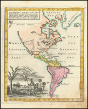
Rare separately published map of America, first published by George Foster in 1735.
Originally issued by George Foster in London ca 1730 under the title A New and Correct Map of America Laid Down According to the Accurate Improvements of Senex, Moll ... Inscribed to His Royal Highness Frederick Prince of Wales. This 1763 edition includes a new cartouche and focuses in on the recent British victory in the French & Indian War, resulting in significant British Territorial gains.
The map shows California as an island, and includes an elaborate native American motif. The map also included the inset maps of Boston, the coastline of Georgia and Port Royal, along with the larger inset map of the North Pole, along with the Cod Fisheries scene.
Rarity
This is the first time we have ever seen this map.
![[French America and the Triangular Trade] L'Amérique Françoise Où son Décrites La France Nouvelle, La France Insulaire, La France Equinoctiale, et autre pais Par P. Du Val d'Abbeville Geographe du Roy . . .](https://storage.googleapis.com/raremaps/img/small/91968.jpg)