


|
||

|

|
|

|
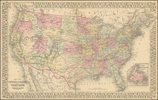
Fascinating Government Map of the United States
Interesting map of the United States, focusing on the Military Forts and Military Districts in the United States.
On the present example, the four military districts west of the Mississippi are highliighted in outline color:
- Department of the West
- Department of the Pacific
- Department of Texas
- Department of New Mexico
Shows also the "Extreme Line of Outposts in 1845" and several major roads to the west. The various military Departments are also named. Includes a number of short lived forts west of the Mississippi.
The map notes Lieutenant Mowry's Route to Los Angeles. This would be Lieutenant Sylvester Mowry (1833-1871) and John Chandler's expedition from the Great Salt Lake to Fort Tejon in 1855. Mowry, a West Point graduate, is most famous as an early advocate for the establishment of the Arizona Territory, who was later arrested as a traitor during the American Civil War. After graduation from West Point, Mowry was assigned to the Pacific Railroad Survey near the Columbia River, serving under Isaac Ingalls Stevens. During the winter of 1854–55 he served under Lieutenant Colonel Edward Steptoe in Utah, during which time Mowry seduced the married niece of Brigham Young, which resulted in his hastily being ordered to lead an expedition from the Great Salt Lake through the Great Basin to Fort Tejon, California.
![The Eagle Map of the United States Engraved For Rudiments of National Knowledge. 1833. [with:] Rudiments of National Knowledge, Presented To The Youth Of The United States, And To Enquiring Foreigners. By A Citizen Of Pennsylvania.](https://storage.googleapis.com/raremaps/img/small/86933.jpg)
![[Los Angeles Olympic] O Limp Hicks Loose Anglaise Calif. 1932](https://storage.googleapis.com/raremaps/img/small/90509.jpg)
![[ English Plantations in North America ] A New Map of the most Considerable Plantations of the English In America Dedicated to His Highness William Duke of Glocester.](https://storage.googleapis.com/raremaps/img/small/98233.jpg)
![[ Military Departments ] Johnson's New Military Map of the United States Forts, Military Posts & all the Military Divisions with Enlarged Plans of the Southern Harbors . . .](https://storage.googleapis.com/raremaps/img/small/101114.jpg)
![[United States Independence After The Revolution] A New Map of North America, with the West India Islands, Divided according to the Preliminary Articles of Peace, Signed at Versailles, 20 Jan. 1783, wherein are particularly Distinguished The United States, and the Several Provinces, Governments &ca, which Compose the British Dominions . . . 1783](https://storage.googleapis.com/raremaps/img/small/70734.jpg)