This item has been sold, but you can enter your email address to be notified if another example becomes available.


|
||

|

|
|

|
Stock# 67903
Description
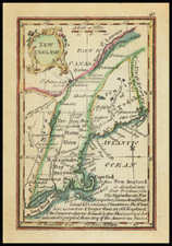
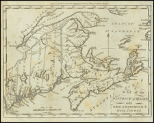
Rare Regional School Girl Map
Finely executed school girl map of the New England States, drawn by Ann M. Messinger.
The map would seem to have been drawn from a map printed by F.J. Huntington in 1830, from an Atlas, designed to illustrate the Malte-Brun school geography. By S. Griswold Goodrich. Hartford, published by F.J. Huntington. Collins and Hannay, New-York; Carter and Hendee, Boston; Towar and Hogan, French and Perkins, Philadelphia ... 1832, published by Goodrich in Hartford, Connecticut.
While maps of the United States and North America appear on the market occasionally, regional maps of this sort are quite rare on the market.
Condition Description
Hand Drawn Map.