|
||

|

|
|

|
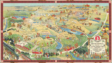
Decorative Bicentennial pictorial map of Casco Bay, published for the Casco Bay Lines Custom House Wharf.
First issued in about 1950, this detailed and vibrant map encapsulates a 60-mile segment of the southern Maine coastline, spanning from Pine Point to the Black Rocks in the picturesque Casco Bay area. Produced as a promotional piece for a local ferry service, the map is an illustrated chronicle of the region's maritime heritage, historical milestones, and architectural marvels. It distinctively illustrates the tales of over a dozen shipwrecks, alongside depictions of coastal lighthouses and significant historical events. Notable features include a depiction of a hot-air balloon at Peak’s Island Amusement Park, a representation of a witch's funeral at Harpswell Neck, and even recorded sightings of sea serpents.
There are two editions of the map, the first (green water) was published in about 1950, while the second (blue water) was published in 1976, bearing the American Bicentennial Logo in the upper right corner.
![[ Mount Desert Island -- Proof Sheet -- George Davidson Copy ]](https://storage.googleapis.com/raremaps/img/small/101360.jpg)