|
||

|

|
|

|
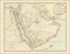
A striking map of Saudi Arabia, Iran, Iraq and Afghanistan and Pakistan showing nice detail. The map shows some detail on adjacent countries, including India, Turkey, and Tartary.
Arabia controls the whole peninsula. Oman, Yemen, Seger, and several other provinces are named. The Qatari peninsula is not shown, typical of maps of this period. The River Aftan, as shown on this map and many other maps of the period, presents a conundrum to historians. While there is a wadi that flows from Kharg [al-Kharj] to the Gulf, it has been dry during the quaternary. There are competing hypothesis that the Aftan is either this wadi, or the record of an old trading route. Socotra, now a UNESCO world heritage site, barely makes it onto the map.
Iran is presented broken into provinces. Extensive detail is given to its features. Beloochistan is outlined in a notably different and stronger color than the rest of the peninsula, perhaps singled out due to the large British influence.
The map is from the first edition of Tanner's Universal Atlas.
![[Mecca and the Kaaba]](https://storage.googleapis.com/raremaps/img/small/79544.jpg)