


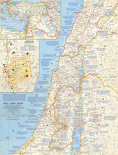
|
||

|

|
|

|
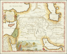
The circa 1680 hand-colored engraved map, Nova Persia Armenia Natoliæ et Arabia Descriptio, by Frederik de Wit is a testament to the intricate art of cartography, presenting a meticulously detailed view of the vast region spanning from the Saudi Peninsula to Afghanistan, centered on the Persian Gulf.
The remarkable depth of geographical details exhibited in the map illustrates De Wit's dedication to precision. This is further augmented by the inclusion of two distinct cartouches, ships sailing the seas, and a striking depiction of an Arab geographer engaged in the accurate measurement of distances using a compass divider.
A standout feature of the map is the lower right cartouche, showcasing a robed woman, her hair coiled into a topknot, presenting an ouroboros to an Arab or Ottoman man, who leans against a stone stele carrying the title of the map. In her other hand, she holds a dial. Her presence, initially mysterious, can be interpreted symbolically. The ouroboros, a serpent eating its own tail, is a potent symbol of cyclicality, eternity, and constant change. Thus, her presentation of this emblem, while she holds a dial in her other hand, suggests a representation of Time itself. In this allegorical reading, she could be imparting a prophecy to the skeptical Muslim ruler: acknowledging the ancient roots of the region while also hinting at the inevitability of change in the future.
In this way, the map not only offers a geographical overview of the Persian Gulf region during the late 17th century, but it also weaves a symbolic narrative of time and transformation, lending additional layers of historical and cultural significance to this already remarkable map.
De Wit (1629 ca.-1706) was a mapmaker and mapseller who was born in Gouda but who worked and died in Amsterdam. He moved to the city in 1648, where he opened a printing operation under the name of The Three Crabs; later, he changed the name of his shop to The White Chart. From the 1660s onward, he published atlases with a variety of maps; he is best known for these atlases and his Dutch town maps. After Frederik’s death in 1706, his wife Maria ran the shop for four years before selling it. Their son, Franciscus, was a stockfish merchant and had no interest in the map shop. At the auction to liquidate the de Wit stock, most of the plates went to Pieter Mortier, whose firm eventually became Covens & Mortier, one of the biggest cartography houses of the eighteenth century.
![[Mecca]](https://storage.googleapis.com/raremaps/img/small/95378.jpg)

![Natoliae Sive Asia Minor [shows Cyprus]](https://storage.googleapis.com/raremaps/img/small/42928.jpg)
![Turcicum Imperium . . . [shows Cyprus]](https://storage.googleapis.com/raremaps/img/small/91206.jpg)