|
||

|

|
|

|
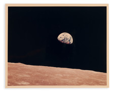
The "First Photo of Earth From Deep Space." An Exceptional Large Format Example With Both Sheets.
A superlative example of one of mankind's most historic images. The most famous of the Lunar Orbiter images and Man's first look at the Earth from the Moon.
This is an example of the large format printing of the photograph, with provenance to the Lunar Orbiter Program at Boeing, as well as contemporary supporting documents.
The photographs are accompanied by a contemporary label reading:
HISTORIC FIRST PHOTO OF EARTH FROM DEEP SPACE." Taken August 23, 1966, by NASA, BOEING, and LUNAR ORBITER I. The crater in frames 593 and 504 at the bottom of the photo is 7 miles across and 6 miles deep. Mount Everest would fit inside it. US East Coast at the upper left, S. Europe toward dark side, and Antarctica at the bottom.
Furthermore, the lot includes the front page of the Seattle Post-Intelligencer from Friday, August 26, 1966, with the image and the tagline "THE EARTH AS SEEN FROM THE MOON"
Rarity
Only one other large-scale example of the Earthrise photo has traded hands in recent years, at Christie's in 2021. This example was larger but appears to be a later printing, and it has no provenance that ties it to the Apollo program. That example made £150,000.
Recently, an 8x10-inch "black letter" NASA photograph of the 1968 Earthrise made £23,750 at auction in London.
Provenance
From the collection of a Seattle-based veteran of Boeing's Public Relations and Advertising Department who joined the company in 1961.
The Lunar Orbiters were a series of five unmanned spacecraft which undertook detailed mapping of the moon in 1966-1967. By taking thousands of photos over five missions, the surface of the moon was able to be mapped down to a meter scale. This would allow for both increased scientific understanding of the moon, as well as helping to identify possible landing sites for the Surveyor and Apollo missions.
The orbiters were the result of a joint bid between Boeing and Eastman Kodak. The Air Force was originally planned to take charge of the imaging operation, but concerns over the classified nature of their camera specifications led to lower-resolution, privately-designed, cameras being used. These ended up working well in part due to an ingenious focusing mechanism, and ninety-nine percent of the surface of the moon, including the dark side of the moon, was successfully mapped.
The orbiters not only provided visual information but also gravitational information. Doppler tracking of the orbiters allowed for gravity anomalies over maria to be measured, allowing for a better understanding of the moon's gravitational field. These measurements showed that both Airy and Pratt isostasy were important on the moon, meaning that topography was both due to compositional and mass differences.
The first three missions focused on surveying the sites for the Apollo landing missions, while the last two focused more on completing the lunar mapping mission. Lunar Orbiter 2 would be the first to photograph the Sea of Tranquility, the landing site for Apollo 11. Each orbiter crashed on the moon several months after its mission ended.
![(San Diego Photograph) 225. San Diego Mission. Oldest in the State. Established 1769 [Original boudoir card format albumen photograph of San Diego Mission and St. Anthony's Indian School Girl's Dormitory]](https://storage.googleapis.com/raremaps/img/small/92622.jpg)

![(San Francisco Photographs) Montgomery Block. Montgomery & Washington Streets, 1856, after Fardon [and] Veranda Saloon, Morris & Mitchell, Washington and Kearny Streets, after Fardon, 1856](https://storage.googleapis.com/raremaps/img/small/85915.jpg)