
The item illustrated and described below is sold, but we
have another example in stock. To view the example which
is currently being offered for sale, click the
"View Details" button below.


|
||

|

|
|

|
Stock# 66719
Description
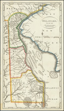
Including Extensive Early Pencil Annotations
Annotated example of Matthew Carey's map of the State of Delaware, from the scarce 1816 edition of Carey's General Atlas.
The map shows counties, early roads, towns and other details.
One of the earliest obtainable maps of the State of Delaware.
![(U.S. Civil War) Panorama des Kriegsschauplatzes [Bird's-Eye View of the Theater of War Showing Virginia, Maryland, Deleware & Columbia]](https://storage.googleapis.com/raremaps/img/small/99760.jpg)
![[ Wilmington, Delaware -- Colonial Manuscript Map and Indenture ]](https://storage.googleapis.com/raremaps/img/small/36737.jpg)
