|
||

|

|
|

|
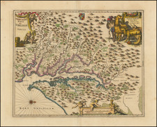
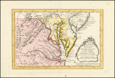
This 1862 bird's-eye view, titled Panorama des Kriegsschauplatzes, is a striking depiction of the Eastern theater of war during the U.S. Civil War. Published by Ernst Jäger in Stuttgart, the map portrays key locations, such as Washington, Richmond, and Baltimore, alongside vital transport routes, fort positions, and significant battle sites. It uniquely incorporates crossed sabers to mark battle locations, with varying numbers indicating the scale or significance of the battles, such as the Battle of Ball's Bluff and First Bull Run.
Interestingly, this map is a German adaptation of John Bachmann’s Panorama of the Seat of the War Birds Eye View of Virginia, Maryland, Delaware and the District of Columbia, first published in 1861. Bachmann's output, celebrated for his beautiful bird's-eye views, significantly influenced subsequent cartographic representations of the Civil War.
![[ Military Departments ] Johnson's New Military Map of the United States Forts, Military Posts & all the Military Divisions with Enlarged Plans of the Southern Harbors . . .](https://storage.googleapis.com/raremaps/img/small/101114.jpg)