|
||

|

|
|

|
Color bird's eye view of East Africa stretching out to the Mediterranean and Europe beyond. The map was made by S.J. Turner and published for the Daily Herald in London.
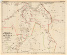
The map shows the political divisions in the Horn of Africa during Italy's conquest of the region. Anglo-Egyptian Sudan, Kenya Colony, and British Somaliland are all still held by the U.K. Italian Somaliland, Libya, and Eritrea are held by the Italians, but Abyssinia is still an independent country.
The map uses an interesting grid-scale to represent distance, with each edge of a square representing roughly 200 miles.
Italian East Africa
This map covers Abyssinia (Ethiopia) just before it became Italian East Africa.
Italian East Africa was an Italian colony established in 1936, consolidating preexisting Italian territories in East Africa with the newly-conquered Empire of Ethiopia.
As is shown on the map, the Italians quickly assumed the imperial trappings of the Empire of Ethiopia; here Vittorio Emanuele III is called "King of Italy and Emperor of Ethiopia" and Pietro Badoglio is "Duke of Addis Abeba". These titles were not recognized outside of Italy, Nazi Germany, and Japan.
The map illustrates the subsidiary divisions of the colony: Somalia, Arrar, Galla-Sidamo, Addis-Abeba, Amhara, and Eritrea.
The colony would be expanded in 1940 with the conquest of French Somalia and British Somalia. In 1942, British and South African forces had captured most of the colony, though an Italian guerrilla campaign continued into the next year.
![IX. b [East Africa]](https://storage.googleapis.com/raremaps/img/small/93300.jpg)
![Carte Routiere de Madagascar et dependances [set of 4 folding maps]](https://storage.googleapis.com/raremaps/img/small/89247.jpg)