|
||

|

|
|

|
Stock# 93300
Description
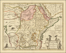
This 1702 map by Johann Ulrich Muller shows a portion of East Africa, focusing on the region known as Abyssinia (present-day Ethiopia). The map provides information on various kingdoms within the region, their main cities, and geographical features. The text on the map can be translated as follows:
The Kingdom of Abyssinia is divided into:
- The Kingdom of Barnagaffo, with the main city Barna, Dafila, Canfila, along with the island of Meroë.
- The Kingdom of Tigremahou, with Tigremahou.
- The Kingdom of Darata.
- Fatigara and Dangali.
- Xoa, Amara, with the main fortress Amara.
- Bora and Bagamedri. And then
- Damut and Narea.
The map presents an overview of the political and geographical landscape in East Africa at the time, with a focus on the various kingdoms and territories within Abyssinia. It offers a valuable historical perspective on the region during the early 18th century.
![[Lake Tanganyika, Lake Victoria and Northwest Tanzania]](https://storage.googleapis.com/raremaps/img/small/63611.jpg)
![[Luanda, Angola] Eroberung der Statt Loando de Sanct Paolo in Angola in Africa. Gelegen](https://storage.googleapis.com/raremaps/img/small/85194.jpg)