The item illustrated and described below is sold, but we
have another example in stock. To view the example which
is currently being offered for sale, click the
"View Details" button below.
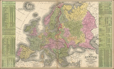
1854 Cowperthwait, Desilver & Butler
$ 195.00


|
||

|

|
|

|
Stock# 6634
Description
Attractive double page map of Europe, colored by countireis. Includes statistical tables for theprincipal countries, kingdoms, empires and states of Europe, the names, titles and other details regarding the European Princes, details on the various armies and navies, governments, religions, sizes, demographics and populations of the 100 largest cities (from London at 2.3 Million to Basle at 24,000). One of the most interesting American published atlas maps of Europe of the period. A few repaired minor tears at the top of the image, but still an attractive example. Normally a $150.00 map.
![[Europe] Parte Occidentale Dell' Europa . . . [and] Parte Orientale Dell' Europa . . . [Coronelli's 2 sheet map of Europe]](https://storage.googleapis.com/raremaps/img/small/94402.jpg)
![[ Through Cooperation to Communism ] Spolupraci ke Komunismu](https://storage.googleapis.com/raremaps/img/small/97646.jpg)
![[ Electors of the Holy Roman Empire ] Ordines Sacri Romani Imp: Ab Ottone III Instituti](https://storage.googleapis.com/raremaps/img/small/99053.jpg)