


|
||

|

|
|

|
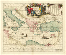
"The most striking and decorative map in de Wit's Orbis Maritimus." (Ginsberg)
This portolan-style chart, Totius Europae Littora Novissime adita. Pascaert vertoonende alle de See-custen van Europa, by Frederick De Wit, circa 1675, offers an exquisite and wide-ranging depiction of Europe's maritime landscape. Stretching from Morocco to the Scandinavian island of Spitsbergen and Iceland, and west to east from Iceland to Dalmatia, this chart encapsulates a remarkable breadth of geography.
Situated in the grand age of Dutch cartography, this chart combines navigational utility with high aesthetic appeal. In the portolan tradition, it emphasizes coastal details over the inland regions, providing mariners with invaluable information about harbors, ports, and coastal cities. Notably, a continuation chart of the Mediterranean extends the map's reach into Africa, ensuring an all-encompassing overview of Europe's maritime milieu.
The chart is distinguished by the elaborate coats of arms representing the key kingdoms of the time - Spain, France, and the Holy Roman Empire - reinforcing the geopolitical import of these maritime spaces. Smaller coats of arms for Norway, Sweden, "Ruslandt" (Russia), and England further enrich the chart's heraldic display, adding a layer of sociopolitical context to the geographical depiction.
De Wit's chart, in all its detail and geographical breadth, serves as both an artifact of 17th-century cartography and a testament to the extensive navigational knowledge amassed during this age of exploration.
Later editions with changes (namely the removal of the coats of arms) were issued until the middle of the 18th century.
De Wit (1629 ca.-1706) was a mapmaker and mapseller who was born in Gouda but who worked and died in Amsterdam. He moved to the city in 1648, where he opened a printing operation under the name of The Three Crabs; later, he changed the name of his shop to The White Chart. From the 1660s onward, he published atlases with a variety of maps; he is best known for these atlases and his Dutch town maps. After Frederik’s death in 1706, his wife Maria ran the shop for four years before selling it. Their son, Franciscus, was a stockfish merchant and had no interest in the map shop. At the auction to liquidate the de Wit stock, most of the plates went to Pieter Mortier, whose firm eventually became Covens & Mortier, one of the biggest cartography houses of the eighteenth century.
![[Heightened with Gold Leaf! -- Paul's Travels ] De Reysen Christi Des Heyland en Pauli met andere syne Bloedgetuygen](https://storage.googleapis.com/raremaps/img/small/72900.jpg)
![[Stop The Fake News!] Halte au Menteurs! Les Colo Bacilles Sement La Haine!](https://storage.googleapis.com/raremaps/img/small/59951.jpg)