|
||

|

|
|

|
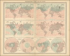
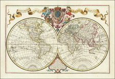
Fine Set of Maps - World & Continents
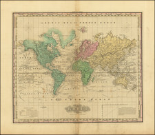
First state of De Vaugondy's map of the World and Continents, published in Paris in 1749.
The set provides a striking group of images of the world as known in the middle of the 18th Century. The world map bears a very curious note at the top left, which translates as follows:
Some authors put here lands which they say to have been discovered by the Admiral de la Fuente in 1640. But the lack of proof and the absolute ignorance where the identity of this Spanish Admiral, show this claim lacks credibility. We know that some Spanish Jesuits have recently asked his Catholic Majesty, the King of Spain, for men and money to continue their discoveries on the coasts of California. We await the success of this next expedition. See Journal, July 1753, page 55.
In French: Quelques auteurs mettent ici des terres quils disent avoir ete decouvertes par l'Amiral de la Fuente en 1640. Mais les dfaut de preuves et l'ignorance absolue ou l'on est de cet Amiral en Espagne, otent toute creance a cette relation. Nous scavons que des Jesuites Espagnols ont demande depuis peu a S.M. Cath. des hommes et de l'argent po9ur poursuivre leurs decouvertes sur les cotes de la Californie. Nous attendons la reussite de cette prochaine expedition. Voyes le journ Oecon Juill 1753. pag 55.
Gilles Robert de Vaugondy (1688-1766) and Didier Robert de Vaugondy (1723-1786) were influential figures in the realm of 18th-century French cartography. Originating from Paris, their contributions to mapmaking were significant during an era of expansive geographical exploration.
Gilles Robert de Vaugondy entered the world of cartography not through family tradition but through personal interest and the budding opportunities of his time. Born in 1688, he worked during a time when Paris was becoming a central hub for cartographic activities. Gilles often incorporated the latest findings from explorers into his maps, making them sought-after for their contemporary relevance. His connections weren't limited to his immediate circle; he frequently interacted with other key mapmakers, staying updated on the latest techniques and findings.
His son, Didier, was born in 1723 and had the advantage of growing up surrounded by maps and globes. While his father was renowned for maps, Didier made a name for himself in the field of globemaking. His globes were some of the most precise and detailed in France, gaining recognition even among the royalty. In addition to his work in cartography and globemaking, Didier had a keen interest in education, especially after the expulsion of the Jesuits from France. He stepped in to produce geographical educational materials, fulfilling a newfound need.
The maps and globes produced by the Vaugondys remain an enduring testament to the peak of French cartography during the Enlightenment. Their works, characterized by precision and the inclusion of contemporary findings, helped to shape our understanding of the world during a transformative period in European history.
![[Pacific Ocean Centric World Map] Mappe-Monde Sur la Projection de Mercator Carte Encyprotype Dediée et Présentée à Monsieur](https://storage.googleapis.com/raremaps/img/small/69294.jpg)