|
||

|

|
|

|
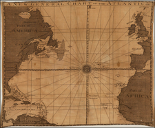
Alexander K. Johnston’s "Physical Map of the Atlantic Ocean": A Pioneering Representation of Oceanic Phenomena
Alexander K. Johnston's map is a testament to the era's intricate knowledge of the Atlantic Ocean. Not only does this map provide a detailed depiction of the vast Atlantic expanse, but it also enlightens the reader on various crucial oceanic phenomena.
The map also tracks the voyages of 18 famous explorers from the 15th to 19th Centuries.
1. Form & Directions of the Currents: Ocean currents play an indispensable role in the overall climate system, and their representation in the map is nothing short of informative. By understanding the direction and form of these currents, one can deduce the patterns of climate, the transfer of heat between continents, and the migration pathways of marine life. For instance, the Gulf Stream, a major current in the Atlantic Ocean, plays a pivotal role in modulating the climate of Western Europe.
2. Distribution of Heat at the Surface: Surface temperatures of oceans are intricately linked with global weather patterns, marine ecosystems, and sea-level changes. Johnston's inclusion of surface temperature distribution not only helps sailors navigate better but also offers early insights into temperature variations across the ocean, which would become a focal point in climate change studies.
3. Navigation & Trade Routes: The Atlantic Ocean has historically been a hub for transcontinental trade and exploration. Highlighting the navigation and trade routes aids mariners in plotting efficient and safe courses. It also offers insights into the global economic system of the time and the importance of maritime trade.
4. Banks, Rocks, &c.: The detailed portrayal of underwater topography, including banks and rocks, is essential for navigation safety. Additionally, these regions often serve as rich fishing grounds, making them economically valuable.
Modern Issues About Surface Temperatures and Its Historical Study: Today, the study of surface temperatures is more critical than ever. Rising oceanic surface temperatures, driven by global warming, have vast implications. They lead to the bleaching of coral reefs, changing migration patterns of marine species, and intensified hurricanes and tropical storms. The relentless increase in oceanic temperatures also results in the thermal expansion of seawater, a significant factor behind rising sea levels, which threatens coastal habitats worldwide.
Historically, studying oceanic surface temperatures was primarily done for navigational purposes. Over the centuries, as our understanding of climate science grew, it became clear that these temperatures are indicators of broader climatic patterns. Early cartographers and oceanographers, like Alexander K. Johnston, laid the foundation for the modern climatic studies that today play a central role in global environmental policy-making.
Includes the following symbols:
- Mail Steam Packet tracks
- Usual Limits of the Currents
- Direction of the Currents
- Tracks to N America, to West Indies, to S. America
- Tracks from S. America
- Tracks to & from the Cape
- Place of the Ship at Noon each day.
- Temperature of ocean surface.
- Temperature of the Ocean in Deg. of Fahrt (Winter and Summer)
- Rocks and other dangers
- Volcanic Eruptions in the Sea
- ce Islands carried to low Latitudes by Polar Currents.
- Steep or bold coasts.
- Flat Coasts.
- Sand Banks.
- Various depth of water in Fathoms
- Track bottles with direction in the Sea.
- Spreading of Sea Weed: (Fucus Natins) in the North Atlantic Ocean, (Sargasso Sea).
![[World -- Terrestrial Globe Gores]](https://storage.googleapis.com/raremaps/img/small/89195.jpg)
![[ Janet Taylor -- Pioneer English Astronomer and Naval Navigation Expert ] Chart to Accompany R. Russel's Diagram of Great Circles / R. Russel's Diagram of Great Circles](https://storage.googleapis.com/raremaps/img/small/98801.jpg)
![Hemisphere Septentrional du Globe Terrestre Veu en concave l'oeil estant au Pole AntArctique . . . 1696 [and] Hemisphere Superieur du Globe Terreste pour l'Horizon de Paris Veu en convexe l'oeil etant pose au zenith et a distance infinie du plan de projection . . . 1697](https://storage.googleapis.com/raremaps/img/small/85541.jpg)