|
||

|

|
|

|
Rare wall map of the world, published in Brussels by the Vandermaelen firm.
An exceptional large map of the world, showcasing Vandermaelen's map skills.
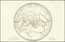
Alaska is Russian America, with no sign of exploration into the interior parts of the the future 50th State. To the north, the coastline of Alaska and the western part of the Polar Sea is frequently incomplete and speculative, reflecting the yet features which would not be discovered for another two decades, by Sir John Franklin and those who would be sent in search of his lost expedition.
In the northwestern part of North America. the discoveries of Lewis & Clark and the Hudson Bay Company, etc. are very much in evidence, with primary rivers and topography beginning to appear among the Indian Tribes listed on the map. Further South, the Adams Onis Treaty Boundary between Mexico and Oregon Territory is poorly defined, but with a highly detailed and nearly entirely fanciful set of Mountains and Rivers draining toward San Francisco Bay, the Central Coast and San Luis Obispo, although the California Missions are all accurately detail.
In Texas, San Felipe deAustin is shown, the first signs of the massive influx of Americans, German Colonists and other emigrants who would flood into the future Republic of Texas over the course of the next 2 decades.
In the Southern Hemisphere, Australia's southwestern coastline is still somewhat inaccurate and there is no sign of either the Australian Gold Rush or the explorations across the continent, which would reshape the mapping of Australia in the 1850s and 1860s.
In Antarctica, an early depiction of the South Shetland Islands appears . The discovery of the South Shetland Islands was first reported in 1819 by Capt. William Smith. Smith Island had beeh known to both American and British sealers as early as 1820.
Philippe Marie Vandermaelen (1795-1869) was a Belgian cartographer and geographer known for his pioneering use of technology and his leadership in establishing the important Establissement geographique de Bruxelles. Born in Brussels, Philippe was obsessed with maps from a young age. He taught himself mathematics, astronomy, and mapmaking and plotted the battles of the Napoleonic wars avidly. He took over his father’s soapmaking business briefly in 1816, but then turned it over to his brother in favor of cartography.
From 1825 to 1827, he released his first atlas, the Atlas universal, which was well received. It was sold in forty installments of ten maps each, with 810 subscribers listed. The atlas contained 387 maps in six volumes at a uniform scale of 1:1.6 million. The maps were intended to be joined and together would create a globe 7.755 meters wide. It was the first atlas to show the entire world on a large uniform scale and was the first atlas produced using lithography. This project served as Vandermaelen’s gateway into intellectual life, gaining him membership in the Royal Academy of Sciences and Belles-Lettres of Brussels (1829).
In 1830, Vandermaelen inherited a laundry from his parents which he converted into the Establissement geographique de Bruxelles, or the Brussels Geographical Establishment. His brother, Jean-Francois, also established a botanical garden on the site. The Establishment had its own lithographic press, one of the first to use the technology for cartography and the first in Belgium. They produced textbooks, surveys, and especially maps of Brussels to be used for urban planning. The complex also housed schools, an ethnographic museum, and a library open to the public. Vandermaelen was passionate about geographic education and saw the Establishment as an open place where people could learn about the world.
In 1836, he was knighted for his services to geography and the intellectual community of Belgium. He died at age 73 in Molenbeek-Saint-Jean, near the Geographical Establishment that he founded. After Vandermaelen’s death, the Geographical Establishment declined, closing its doors in 1880. The extraordinary collection they had amassed passed to several institutions, most importantly the Royal Library of Belgium.
![Карта Часовыхъ Поясовъ. [Map of Time Zones]](https://storage.googleapis.com/raremaps/img/small/95040.jpg)
![[Medieval World Map] Das ist die mapa mudi und alle Land un Kungkreich wie sie ligend in der ganze Welt](https://storage.googleapis.com/raremaps/img/small/102356.jpg)
![Eastern Hemisphere [with] Western Hemisphere](https://storage.googleapis.com/raremaps/img/small/98321.jpg)